Socorro geodata
Socorro (Caraga) is a seat of a third-order administrative division; located in Philippines in Asia/Manila (GMT+8) time zone. With population of 9,743 people, there are 627 cities with bigger population in this country. Compared to other cities in Philippines, 72.4% of cities are located further ↑North; 97.4% of cities are located further ←West and 55.6% of cities have lower elevation than Socorro. Note1


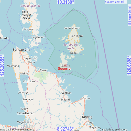
Socorro GPS coordinates[2]
9° 37' 17.004" North, 125° 58' 0.012" East
| Map corner | latitude | longitude |
|---|---|---|
| Upper-left | 10.3139°, | 125.26355° |
| Center: | 9.62139°, | 125.96667° |
| Lower-right: | 8.92746°, | 126.6698° |
| Map W x H: | 154.2×154.2 km | = 95.8×95.8mi |
| max Lat: | 20.78733° ⇑72.4% North |
| Socorro: | 9.62139° |
| min Lat: | ⇓27.6% South 4.65442° |
| min Long | Socorro | max Long |
| 117.04868° | 125.96667° | 126.58417° |
| W 97.4%⇐ | ⇒2.6% E |
Elevation
Elevation of Socorro is 28 m = 92 ft, and this is 59.9 m = 197 ft below average elevation for this country.
| Max E: |
2262 m = 7421 ft | 44.4% |
| Avg. | 87.9 m = 288 ft | |
| Socorro | 28 m = 92 ft | |
Min E: |
-2 m = -7 ft | 55.6% |
See also: Philippines elevation on elevation.city.
Geographical zone
Socorro is located in North Torrid zone (between Equator and Tropic of Cancer). Distance of Equator is 1069.8 km =664.7 mi to South.| Distance of | km | miles | from Socorro |
|---|---|---|---|
| North Pole | 8937.3 | 5553.4 | to North |
| Arctic Circle | 6331.4 | 3934.1 | to North |
| Tropic Cancer | 1536.1 | 954.5 | to North |
| Equator | 1069.8 | 664.7 | to South |


Nearby cities:
15 places around Socorro: (largest is in red/bold)
• Adlay
24.7 km =15.3 mi,  197°
197°
• Bacuag
36 km =22.4 mi,  267°
267°
• Cantilan
32 km =19.9 mi,  177°
177°
• Carrascal
28 km =17.4 mi, 183°
• Claver
26.2 km =16.3 mi,  258°
258°
• Dapa
18 km =11.2 mi,  31°
31°
• Del Carmen, Surigao del Norte
27.6 km =17.1 mi,  0°
0°
• General Luna
27.8 km =17.3 mi,  49°
49°
• Gigaquit
29.7 km =18.5 mi, 264°
• Libas
29.2 km =18.1 mi, 3°
• Panikian
32.7 km =20.3 mi,  186°
186°
• Pilar
30.7 km =19.1 mi, 28°
• San Benito
37.7 km =23.4 mi,  6°
6°
• San Isidro
37.5 km =23.3 mi,  20°
20°
• Union
21.8 km =13.5 mi, 46°
Sources, notices
• [Note1] Compared only with cities in Philippines existing in our database
• [Src1] Map data: © OpenStreetMap contributors (CC-BY-SA)
• [Src2] Other city data from geonames.org with taken over terms of usage.
• [Src3] Geographical zone / Annual Mean Temperature by Robert A. Rohde @ Wikipedia
