Abra de Ilog geodata
Abra de Ilog (Mimaropa) is a seat of a third-order administrative division; located in Philippines in Asia/Manila (GMT+8) time zone. With population of 2,971 people, there are 2566 cities with bigger population in this country. Compared to other cities in Philippines, 61.7% of cities are located further ↓South; 84.1% of cities are located further →East and 50.3% of cities have higher elevation than Abra de Ilog. Note1
Administrative division(s):
- Level 1: Mimaropa
- Level 2: Province of Mindoro Occidental
- Level 3: Abra De Ilog


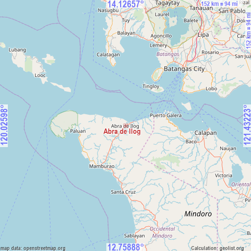
Abra de Ilog GPS coordinates[2]
13° 26' 37.32" North, 120° 43' 44.76" East
| Map corner | latitude | longitude |
|---|---|---|
| Upper-left | 14.12657°, | 120.02598° |
| Center: | 13.4437°, | 120.7291° |
| Lower-right: | 12.75888°, | 121.43223° |
| Map W x H: | 152.1×152.1 km | = 94.5×94.5mi |
| max Lat: | 20.78733° ⇑38.3% North |
| Abra de Ilog: | 13.4437° |
| min Lat: | ⇓61.7% South 4.65442° |
| min Long | Abra de Ilog | max Long |
| 117.04868° | 120.7291° | 126.58417° |
| W 15.9%⇐ | ⇒84.1% E |
Elevation
Elevation of Abra de Ilog is 23 m = 75 ft, and this is 64.9 m = 213 ft below average elevation for this country.
| Max E: |
2262 m = 7421 ft | 50.3% |
| Avg. | 87.9 m = 288 ft | |
| Abra de Ilog | 23 m = 75 ft | |
Min E: |
-2 m = -7 ft | 49.7% |
See also: Philippines elevation on elevation.city.
Geographical zone
Abra de Ilog is located in North Torrid zone (between Equator and Tropic of Cancer). Distance of this Northern Tropic circle is 1111.1 km =690.4 mi to North.| Distance of | km | miles | from Abra de Ilog |
|---|---|---|---|
| North Pole | 8512.3 | 5289.3 | to North |
| Arctic Circle | 5906.4 | 3670.1 | to North |
| Tropic Cancer | 1111.1 | 690.4 | to North |
| Equator | 1494.8 | 928.8 | to South |


Nearby cities:
15 places around Abra de Ilog: (largest is in red/bold)
• Balatero
22.1 km =13.7 mi,  72°
72°
• Cabacao
14.2 km =8.8 mi,  212°
212°
• Dulangan
27.3 km =17 mi,  84°
84°
• Harrison
32 km =19.9 mi,  271°
271°
• Lumangbayan
33.2 km =20.6 mi,  94°
94°
• Mamburao
28.4 km =17.6 mi, 210°
• Odala
10.8 km =6.7 mi, 69°
• Paluan
29 km =18 mi,  263°
263°
• Puerto Galera
24.9 km =15.5 mi, 74°
• Sabang
27.4 km =17 mi, 74°
• San Teodoro
30.9 km =19.2 mi, 92°
• Tabinay
25.1 km =15.6 mi, 78°
• Tayaman
29.2 km =18.1 mi,  215°
215°
• Tingloy
28.6 km =17.8 mi,  32°
32°
• Wawa
2.7 km =1.7 mi,  36°
36°
Sources, notices
• [Note1] Compared only with cities in Philippines existing in our database
• [Src1] Map data: © OpenStreetMap contributors (CC-BY-SA)
• [Src2] Other city data from geonames.org with taken over terms of usage.
• [Src3] Geographical zone / Annual Mean Temperature by Robert A. Rohde @ Wikipedia
