Paluan geodata
Paluan (Mimaropa) is a seat of a third-order administrative division; located in Philippines in Asia/Manila (GMT+8) time zone. With population of 4,549 people, there are 1468 cities with bigger population in this country. Compared to other cities in Philippines, 61.4% of cities are located further ↓South; 91.7% of cities are located further →East and 73.2% of cities have higher elevation than Paluan. Note1
Administrative division(s):
- Level 1: Mimaropa
- Level 2: Province of Mindoro Occidental
- Level 3: Paluan


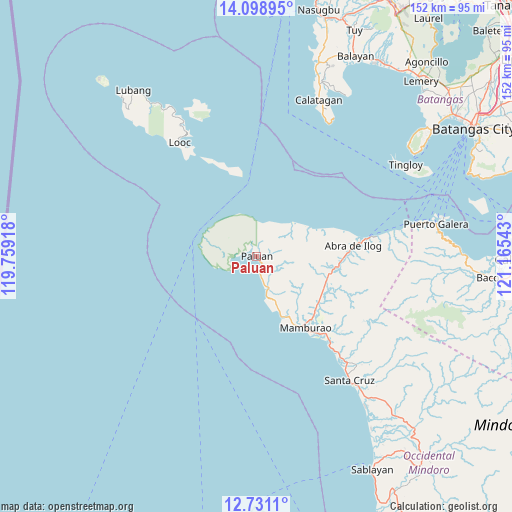
Paluan GPS coordinates[2]
13° 24' 57.6" North, 120° 27' 44.28" East
| Map corner | latitude | longitude |
|---|---|---|
| Upper-left | 14.09895°, | 119.75918° |
| Center: | 13.416°, | 120.4623° |
| Lower-right: | 12.7311°, | 121.16543° |
| Map W x H: | 152.1×152.1 km | = 94.5×94.5mi |
| max Lat: | 20.78733° ⇑38.6% North |
| Paluan: | 13.416° |
| min Lat: | ⇓61.4% South 4.65442° |
| min Long | Paluan | max Long |
| 117.04868° | 120.4623° | 126.58417° |
| W 8.3%⇐ | ⇒91.7% E |
Elevation
Elevation of Paluan is 11 m = 36 ft, and this is 76.9 m = 252 ft below average elevation for this country.
| Max E: |
2262 m = 7421 ft | 73.2% |
| Avg. | 87.9 m = 288 ft | |
| Paluan | 11 m = 36 ft | |
Min E: |
-2 m = -7 ft | 26.8% |
See also: Philippines elevation on elevation.city.
Geographical zone
Paluan is located in North Torrid zone (between Equator and Tropic of Cancer). Distance of this Northern Tropic circle is 1114.2 km =692.3 mi to North.| Distance of | km | miles | from Paluan |
|---|---|---|---|
| North Pole | 8515.3 | 5291.2 | to North |
| Arctic Circle | 5909.5 | 3672 | to North |
| Tropic Cancer | 1114.2 | 692.3 | to North |
| Equator | 1491.7 | 926.9 | to South |


Nearby cities:
15 places around Paluan: (largest is in red/bold)
• Abra de Ilog
29 km =18 mi,  83°
83°
• Balatero
50.9 km =31.6 mi, 79°
• Balitoc
53.1 km =33 mi,  20°
20°
• Cabacao
23.1 km =14.4 mi,  112°
112°
• Calatagan
49.8 km =30.9 mi, 21°
• Harrison
4.9 km =3 mi,  320°
320°
• Looc
40.9 km =25.4 mi,  325°
325°
• Mamburao
25.9 km =16.1 mi,  145°
145°
• Odala
39.5 km =24.5 mi, 80°
• Puerto Galera
53.8 km =33.4 mi, 79°
• Santa Cruz
47.4 km =29.5 mi,  143°
143°
• Tayaman
23.9 km =14.9 mi, 150°
• Tilik
52.6 km =32.7 mi, 327°
• Tingloy
51.9 km =32.2 mi,  58°
58°
• Wawa
30.9 km =19.2 mi, 80°
Sources, notices
• [Note1] Compared only with cities in Philippines existing in our database
• [Src1] Map data: © OpenStreetMap contributors (CC-BY-SA)
• [Src2] Other city data from geonames.org with taken over terms of usage.
• [Src3] Geographical zone / Annual Mean Temperature by Robert A. Rohde @ Wikipedia
