San Jose geodata
San Jose (Cagayan Valley) is a populated place; located in Philippines in Asia/Manila (GMT+8) time zone. With population of 4,533 people, there are 1473 cities with bigger population in this country. Compared to other cities in Philippines, 97.9% of cities are located further ↓South; 61.8% of cities are located further →East and 58.8% of cities have lower elevation than San Jose. Note1


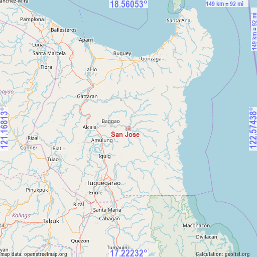
San Jose GPS coordinates[2]
17° 53' 33.684" North, 121° 52' 16.5" East
| Map corner | latitude | longitude |
|---|---|---|
| Upper-left | 18.56053°, | 121.16813° |
| Center: | 17.89269°, | 121.87125° |
| Lower-right: | 17.22232°, | 122.57438° |
| Map W x H: | 148.8×148.8 km | = 92.5×92.5mi |
| max Lat: | 20.78733° ⇑2.1% North |
| San Jose: | 17.89269° |
| min Lat: | ⇓97.9% South 4.65442° |
| min Long | San Jose | max Long |
| 117.04868° | 121.87125° | 126.58417° |
| W 38.2%⇐ | ⇒61.8% E |
Elevation
Elevation of San Jose is 32 m = 105 ft, and this is 55.9 m = 183 ft below average elevation for this country.
| Max E: |
2262 m = 7421 ft | 41.2% |
| Avg. | 87.9 m = 288 ft | |
| San Jose | 32 m = 105 ft | |
Min E: |
-2 m = -7 ft | 58.8% |
See also: Philippines elevation on elevation.city.
Geographical zone
San Jose is located in North Torrid zone (between Equator and Tropic of Cancer). Distance of this Northern Tropic circle is 616.4 km =383 mi to North.| Distance of | km | miles | from San Jose |
|---|---|---|---|
| North Pole | 8017.6 | 4981.9 | to North |
| Arctic Circle | 5411.7 | 3362.7 | to North |
| Tropic Cancer | 616.4 | 383 | to North |
| Equator | 1989.5 | 1236.2 | to South |


Nearby cities:
15 places around San Jose: (largest is in red/bold)
• Aggugaddah
22.6 km =14 mi,  198°
198°
• Alcala
22.8 km =14.2 mi,  272°
272°
• Amulung
16.8 km =10.4 mi,  247°
247°
• Awallan
5.7 km =3.5 mi,  51°
51°
• Bitag Grande
2.5 km =1.6 mi,  295°
295°
• Calantac
15.8 km =9.8 mi,  276°
276°
• Capissayan Sur
18.5 km =11.5 mi,  342°
342°
• Dalaoig
17.7 km =11 mi,  290°
290°
• Estefania
18.8 km =11.7 mi,  236°
236°
• Iguig
21.3 km =13.2 mi,  222°
222°
• Lapi
19.8 km =12.3 mi,  171°
171°
• Manga
21.3 km =13.2 mi,  183°
183°
• Minanga Norte
21 km =13 mi,  225°
225°
• Quibal
20.7 km =12.9 mi, 197°
• Taguing
13.7 km =8.5 mi, 295°
Sources, notices
• [Note1] Compared only with cities in Philippines existing in our database
• [Src1] Map data: © OpenStreetMap contributors (CC-BY-SA)
• [Src2] Other city data from geonames.org with taken over terms of usage.
• [Src3] Geographical zone / Annual Mean Temperature by Robert A. Rohde @ Wikipedia
