Awallan geodata
Awallan (Cagayan Valley) is a populated place; located in Philippines in Asia/Manila (GMT+8) time zone. With population of 2,144 people, there are 4001 cities with bigger population in this country. Compared to other cities in Philippines, 98.1% of cities are located further ↓South; 61.4% of cities are located further →East and 64.7% of cities have lower elevation than Awallan. Note1


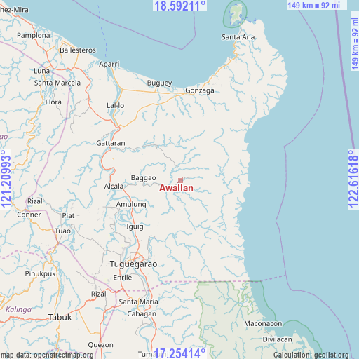
Awallan GPS coordinates[2]
17° 55' 27.804" North, 121° 54' 46.98" East
| Map corner | latitude | longitude |
|---|---|---|
| Upper-left | 18.59211°, | 121.20993° |
| Center: | 17.92439°, | 121.91305° |
| Lower-right: | 17.25414°, | 122.61618° |
| Map W x H: | 148.8×148.8 km | = 92.5×92.5mi |
| max Lat: | 20.78733° ⇑1.9% North |
| Awallan: | 17.92439° |
| min Lat: | ⇓98.1% South 4.65442° |
| min Long | Awallan | max Long |
| 117.04868° | 121.91305° | 126.58417° |
| W 38.6%⇐ | ⇒61.4% E |
Elevation
Elevation of Awallan is 41 m = 135 ft, and this is 46.9 m = 154 ft below average elevation for this country.
| Max E: |
2262 m = 7421 ft | 35.3% |
| Avg. | 87.9 m = 288 ft | |
| Awallan | 41 m = 135 ft | |
Min E: |
-2 m = -7 ft | 64.7% |
See also: Philippines elevation on elevation.city.
Geographical zone
Awallan is located in North Torrid zone (between Equator and Tropic of Cancer). Distance of this Northern Tropic circle is 612.9 km =380.8 mi to North.| Distance of | km | miles | from Awallan |
|---|---|---|---|
| North Pole | 8014.1 | 4979.7 | to North |
| Arctic Circle | 5408.2 | 3360.5 | to North |
| Tropic Cancer | 612.9 | 380.8 | to North |
| Equator | 1993 | 1238.4 | to South |


Nearby cities:
15 places around Awallan: (largest is in red/bold)
• Amulung
22.3 km =13.9 mi,  243°
243°
• Bitag Grande
7.1 km =4.4 mi,  249°
249°
• Calantac
20.2 km =12.6 mi,  265°
265°
• Calaoagan
24 km =14.9 mi,  303°
303°
• Capissayan Sur
17.3 km =10.7 mi,  324°
324°
• Dalaoig
21.2 km =13.2 mi,  277°
277°
• Estefania
24.4 km =15.2 mi, 235°
• Iguig
26.9 km =16.7 mi,  224°
224°
• Lapi
23.2 km =14.4 mi,  183°
183°
• Manga
25.4 km =15.8 mi,  192°
192°
• Minanga Norte
26.6 km =16.5 mi,  226°
226°
• Palagao Norte
24.5 km =15.2 mi, 302°
• Quibal
25.6 km =15.9 mi,  204°
204°
• San Jose
5.7 km =3.5 mi, 231°
• Taguing
16.9 km =10.5 mi, 278°
Sources, notices
• [Note1] Compared only with cities in Philippines existing in our database
• [Src1] Map data: © OpenStreetMap contributors (CC-BY-SA)
• [Src2] Other city data from geonames.org with taken over terms of usage.
• [Src3] Geographical zone / Annual Mean Temperature by Robert A. Rohde @ Wikipedia
