San Jacinto geodata
San Jacinto (Central Luzon) is a populated place; located in Philippines in Asia/Manila (GMT+8) time zone. With population of 2,771 people, there are 2840 cities with bigger population in this country. Compared to other cities in Philippines, 82.1% of cities are located further ↓South; 85.8% of cities are located further →East and 59.5% of cities have lower elevation than San Jacinto. Note1


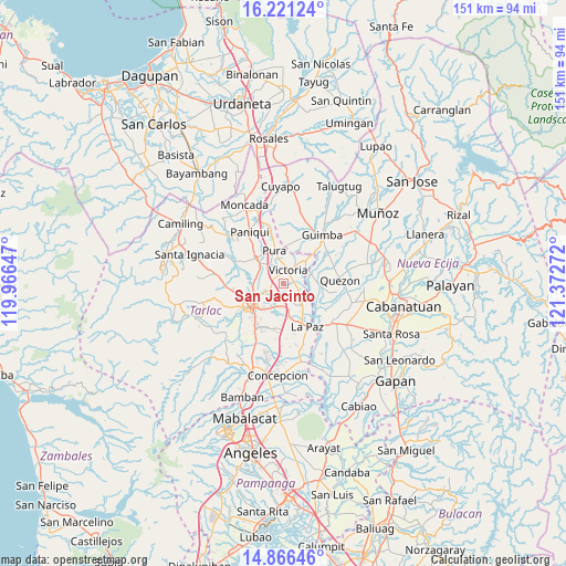
San Jacinto GPS coordinates[2]
15° 32' 41.856" North, 120° 40' 10.524" East
| Map corner | latitude | longitude |
|---|---|---|
| Upper-left | 16.22124°, | 119.96647° |
| Center: | 15.54496°, | 120.66959° |
| Lower-right: | 14.86646°, | 121.37272° |
| Map W x H: | 150.6×150.6 km | = 93.6×93.6mi |
| max Lat: | 20.78733° ⇑17.9% North |
| San Jacinto: | 15.54496° |
| min Lat: | ⇓82.1% South 4.65442° |
| min Long | San Jacinto | max Long |
| 117.04868° | 120.66959° | 126.58417° |
| W 14.2%⇐ | ⇒85.8% E |
Elevation
Elevation of San Jacinto is 33 m = 108 ft, and this is 54.9 m = 180 ft below average elevation for this country.
| Max E: |
2262 m = 7421 ft | 40.5% |
| Avg. | 87.9 m = 288 ft | |
| San Jacinto | 33 m = 108 ft | |
Min E: |
-2 m = -7 ft | 59.5% |
See also: Philippines elevation on elevation.city.
Geographical zone
San Jacinto is located in North Torrid zone (between Equator and Tropic of Cancer). Distance of this Northern Tropic circle is 877.5 km =545.3 mi to North.| Distance of | km | miles | from San Jacinto |
|---|---|---|---|
| North Pole | 8278.6 | 5144.1 | to North |
| Arctic Circle | 5672.7 | 3524.9 | to North |
| Tropic Cancer | 877.5 | 545.3 | to North |
| Equator | 1728.4 | 1074 | to South |


Nearby cities:
15 places around San Jacinto: (largest is in red/bold)
• Amacalan
7.5 km =4.7 mi,  303°
303°
• Bakulong
3.4 km =2.1 mi,  256°
256°
• Balayang
2.7 km =1.7 mi,  79°
79°
• Balingcanaway
7.2 km =4.5 mi,  166°
166°
• Bularit
5.7 km =3.5 mi, 296°
• Calibungan
8.3 km =5.2 mi,  44°
44°
• Estipona
6.1 km =3.8 mi,  325°
325°
• Lomboy
7.7 km =4.8 mi,  138°
138°
• Maluid
1.9 km =1.2 mi,  285°
285°
• Matayumtayum
5.3 km =3.3 mi,  126°
126°
• San Manuel
6.1 km =3.8 mi,  184°
184°
• San Nicolas
4.4 km =2.7 mi,  9°
9°
• San Pascual
4.8 km =3 mi, 183°
• Tariji
6.5 km =4 mi,  245°
245°
• Victoria
3.9 km =2.4 mi,  20°
20°
Sources, notices
• [Note1] Compared only with cities in Philippines existing in our database
• [Src1] Map data: © OpenStreetMap contributors (CC-BY-SA)
• [Src2] Other city data from geonames.org with taken over terms of usage.
• [Src3] Geographical zone / Annual Mean Temperature by Robert A. Rohde @ Wikipedia
