Bakulong geodata
Bakulong (Central Luzon) is a populated place; located in Philippines in Asia/Manila (GMT+8) time zone. With population of 3,655 people, there are 1944 cities with bigger population in this country. Compared to other cities in Philippines, 82% of cities are located further ↓South; 86.9% of cities are located further →East and 63.6% of cities have lower elevation than Bakulong. Note1


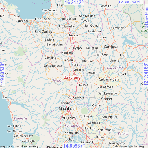
Bakulong GPS coordinates[2]
15° 32' 16.44" North, 120° 38' 18.6" East
| Map corner | latitude | longitude |
|---|---|---|
| Upper-left | 16.2142°, | 119.93538° |
| Center: | 15.5379°, | 120.6385° |
| Lower-right: | 14.85937°, | 121.34163° |
| Map W x H: | 150.6×150.6 km | = 93.6×93.6mi |
| max Lat: | 20.78733° ⇑18% North |
| Bakulong: | 15.5379° |
| min Lat: | ⇓82% South 4.65442° |
| min Long | Bakulong | max Long |
| 117.04868° | 120.6385° | 126.58417° |
| W 13.1%⇐ | ⇒86.9% E |
Elevation
Elevation of Bakulong is 39 m = 128 ft, and this is 48.9 m = 160 ft below average elevation for this country.
| Max E: |
2262 m = 7421 ft | 36.4% |
| Avg. | 87.9 m = 288 ft | |
| Bakulong | 39 m = 128 ft | |
Min E: |
-2 m = -7 ft | 63.6% |
See also: Philippines elevation on elevation.city.
Geographical zone
Bakulong is located in North Torrid zone (between Equator and Tropic of Cancer). Distance of this Northern Tropic circle is 878.3 km =545.8 mi to North.| Distance of | km | miles | from Bakulong |
|---|---|---|---|
| North Pole | 8279.4 | 5144.6 | to North |
| Arctic Circle | 5673.5 | 3525.3 | to North |
| Tropic Cancer | 878.3 | 545.8 | to North |
| Equator | 1727.7 | 1073.5 | to South |


Nearby cities:
15 places around Bakulong: (largest is in red/bold)
• Amacalan
5.7 km =3.5 mi,  328°
328°
• Balayang
6.1 km =3.8 mi,  77°
77°
• Bularit
3.8 km =2.4 mi, 331°
• Cardona
6.5 km =4 mi,  306°
306°
• Estipona
5.8 km =3.6 mi,  359°
359°
• Maluid
2 km =1.2 mi,  50°
50°
• Matayumtayum
8 km =5 mi,  107°
107°
• San Jacinto
3.4 km =2.1 mi, 76°
• San Manuel
6 km =3.7 mi,  151°
151°
• San Nicolas
6.6 km =4.1 mi,  38°
38°
• San Pascual
5.1 km =3.2 mi,  142°
142°
• Sinait
5.7 km =3.5 mi,  268°
268°
• Tariji
3.2 km =2 mi,  234°
234°
• Tarlac City
7.8 km =4.8 mi,  214°
214°
• Victoria
6.4 km =4 mi, 46°
Sources, notices
• [Note1] Compared only with cities in Philippines existing in our database
• [Src1] Map data: © OpenStreetMap contributors (CC-BY-SA)
• [Src2] Other city data from geonames.org with taken over terms of usage.
• [Src3] Geographical zone / Annual Mean Temperature by Robert A. Rohde @ Wikipedia
