Matayumtayum geodata
Matayumtayum (Central Luzon) is a populated place; located in Philippines in Asia/Manila (GMT+8) time zone. With population of 2,730 people, there are 2892 cities with bigger population in this country. Compared to other cities in Philippines, 81.8% of cities are located further ↓South; 84.7% of cities are located further →East and 52.3% of cities have lower elevation than Matayumtayum. Note1


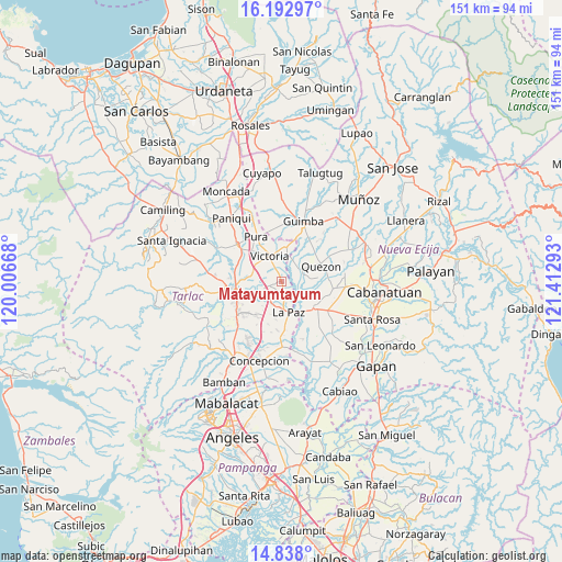
Matayumtayum GPS coordinates[2]
15° 30' 59.76" North, 120° 42' 35.28" East
| Map corner | latitude | longitude |
|---|---|---|
| Upper-left | 16.19297°, | 120.00668° |
| Center: | 15.5166°, | 120.7098° |
| Lower-right: | 14.838°, | 121.41293° |
| Map W x H: | 150.7×150.7 km | = 93.6×93.6mi |
| max Lat: | 20.78733° ⇑18.2% North |
| Matayumtayum: | 15.5166° |
| min Lat: | ⇓81.8% South 4.65442° |
| min Long | Matayumtayum | max Long |
| 117.04868° | 120.7098° | 126.58417° |
| W 15.3%⇐ | ⇒84.7% E |
Elevation
Elevation of Matayumtayum is 25 m = 82 ft, and this is 62.9 m = 206 ft below average elevation for this country.
| Max E: |
2262 m = 7421 ft | 47.7% |
| Avg. | 87.9 m = 288 ft | |
| Matayumtayum | 25 m = 82 ft | |
Min E: |
-2 m = -7 ft | 52.3% |
See also: Philippines elevation on elevation.city.
Geographical zone
Matayumtayum is located in North Torrid zone (between Equator and Tropic of Cancer). Distance of this Northern Tropic circle is 880.6 km =547.2 mi to North.| Distance of | km | miles | from Matayumtayum |
|---|---|---|---|
| North Pole | 8281.8 | 5146.1 | to North |
| Arctic Circle | 5675.9 | 3526.8 | to North |
| Tropic Cancer | 880.6 | 547.2 | to North |
| Equator | 1725.3 | 1072.1 | to South |


Nearby cities:
15 places around Matayumtayum: (largest is in red/bold)
• Amucao
6.4 km =4 mi,  203°
203°
• Bakulong
8 km =5 mi,  287°
287°
• Balayang
4 km =2.5 mi,  335°
335°
• Balingcanaway
4.6 km =2.9 mi,  214°
214°
• Bundoc
3.5 km =2.2 mi,  166°
166°
• Licab
6.5 km =4 mi,  62°
62°
• Lomboy
2.8 km =1.7 mi,  163°
163°
• Maluid
7.1 km =4.4 mi,  300°
300°
• San Cristobal
7.4 km =4.6 mi, 55°
• San Jacinto
5.3 km =3.3 mi,  306°
306°
• San Manuel
5.6 km =3.5 mi,  238°
238°
• San Pascual
4.9 km =3 mi,  249°
249°
• Santa Lucia
7.9 km =4.9 mi,  119°
119°
• Victoria
7.4 km =4.6 mi, 336°
• Villarosa
5.7 km =3.5 mi,  49°
49°
Sources, notices
• [Note1] Compared only with cities in Philippines existing in our database
• [Src1] Map data: © OpenStreetMap contributors (CC-BY-SA)
• [Src2] Other city data from geonames.org with taken over terms of usage.
• [Src3] Geographical zone / Annual Mean Temperature by Robert A. Rohde @ Wikipedia
