Amacalan geodata
Amacalan (Central Luzon) is a populated place; located in Philippines in Asia/Manila (GMT+8) time zone. With population of 2,693 people, there are 2957 cities with bigger population in this country. Compared to other cities in Philippines, 82.5% of cities are located further ↓South; 87.7% of cities are located further →East and 60.9% of cities have lower elevation than Amacalan. Note1


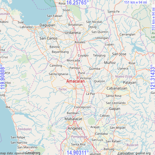
Amacalan GPS coordinates[2]
15° 34' 53.4" North, 120° 36' 40.32" East
| Map corner | latitude | longitude |
|---|---|---|
| Upper-left | 16.25765°, | 119.90808° |
| Center: | 15.5815°, | 120.6112° |
| Lower-right: | 14.90311°, | 121.31433° |
| Map W x H: | 150.6×150.6 km | = 93.6×93.6mi |
| max Lat: | 20.78733° ⇑17.5% North |
| Amacalan: | 15.5815° |
| min Lat: | ⇓82.5% South 4.65442° |
| min Long | Amacalan | max Long |
| 117.04868° | 120.6112° | 126.58417° |
| W 12.3%⇐ | ⇒87.7% E |
Elevation
Elevation of Amacalan is 35 m = 115 ft, and this is 52.9 m = 174 ft below average elevation for this country.
| Max E: |
2262 m = 7421 ft | 39.1% |
| Avg. | 87.9 m = 288 ft | |
| Amacalan | 35 m = 115 ft | |
Min E: |
-2 m = -7 ft | 60.9% |
See also: Philippines elevation on elevation.city.
Geographical zone
Amacalan is located in North Torrid zone (between Equator and Tropic of Cancer). Distance of this Northern Tropic circle is 873.4 km =542.7 mi to North.| Distance of | km | miles | from Amacalan |
|---|---|---|---|
| North Pole | 8274.6 | 5141.6 | to North |
| Arctic Circle | 5668.7 | 3522.4 | to North |
| Tropic Cancer | 873.4 | 542.7 | to North |
| Equator | 1732.5 | 1076.5 | to South |


Nearby cities:
15 places around Amacalan: (largest is in red/bold)
• Bakulong
5.7 km =3.5 mi,  148°
148°
• Balayang
9.6 km =6 mi,  111°
111°
• Balite
7.7 km =4.8 mi,  25°
25°
• Buenlag
6 km =3.7 mi,  328°
328°
• Bularit
1.9 km =1.2 mi,  142°
142°
• Cardona
2.5 km =1.6 mi,  245°
245°
• Estipona
3 km =1.9 mi,  71°
71°
• Gerona
3.1 km =1.9 mi, 332°
• Maluid
5.7 km =3.5 mi,  128°
128°
• Pura
6.2 km =3.9 mi,  39°
39°
• San Jacinto
7.5 km =4.7 mi,  123°
123°
• San Nicolas
7 km =4.3 mi,  87°
87°
• Sinait
5.7 km =3.5 mi,  209°
209°
• Tariji
6.7 km =4.2 mi,  177°
177°
• Victoria
7.6 km =4.7 mi, 93°
Sources, notices
• [Note1] Compared only with cities in Philippines existing in our database
• [Src1] Map data: © OpenStreetMap contributors (CC-BY-SA)
• [Src2] Other city data from geonames.org with taken over terms of usage.
• [Src3] Geographical zone / Annual Mean Temperature by Robert A. Rohde @ Wikipedia
