San Pascual geodata
San Pascual (Central Luzon) is a populated place; located in Philippines in Asia/Manila (GMT+8) time zone. With population of 2,467 people, there are 3354 cities with bigger population in this country. Compared to other cities in Philippines, 81.8% of cities are located further ↓South; 85.8% of cities are located further →East and 59.5% of cities have lower elevation than San Pascual. Note1
Administrative division(s):
- Level 1: Central Luzon
- Level 2: Province of Tarlac
- Level 3: City of Tarlac


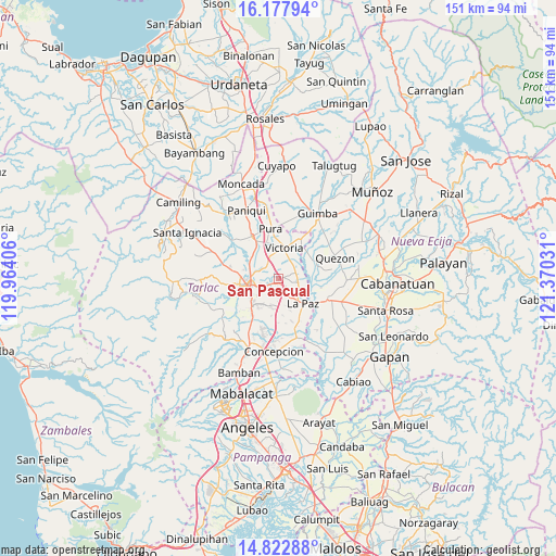
San Pascual GPS coordinates[2]
15° 30' 5.472" North, 120° 40' 1.848" East
| Map corner | latitude | longitude |
|---|---|---|
| Upper-left | 16.17794°, | 119.96406° |
| Center: | 15.50152°, | 120.66718° |
| Lower-right: | 14.82288°, | 121.37031° |
| Map W x H: | 150.7×150.7 km | = 93.6×93.6mi |
| max Lat: | 20.78733° ⇑18.2% North |
| San Pascual: | 15.50152° |
| min Lat: | ⇓81.8% South 4.65442° |
| min Long | San Pascual | max Long |
| 117.04868° | 120.66718° | 126.58417° |
| W 14.2%⇐ | ⇒85.8% E |
Elevation
Elevation of San Pascual is 33 m = 108 ft, and this is 54.9 m = 180 ft below average elevation for this country.
| Max E: |
2262 m = 7421 ft | 40.5% |
| Avg. | 87.9 m = 288 ft | |
| San Pascual | 33 m = 108 ft | |
Min E: |
-2 m = -7 ft | 59.5% |
See also: Philippines elevation on elevation.city.
Geographical zone
San Pascual is located in North Torrid zone (between Equator and Tropic of Cancer). Distance of this Northern Tropic circle is 882.3 km =548.2 mi to North.| Distance of | km | miles | from San Pascual |
|---|---|---|---|
| North Pole | 8283.5 | 5147.1 | to North |
| Arctic Circle | 5677.6 | 3527.9 | to North |
| Tropic Cancer | 882.3 | 548.2 | to North |
| Equator | 1723.6 | 1071 | to South |


Nearby cities:
15 places around San Pascual: (largest is in red/bold)
• Amucao
4.6 km =2.9 mi,  153°
153°
• Bakulong
5.1 km =3.2 mi,  322°
322°
• Balayang
6.1 km =3.8 mi,  28°
28°
• Balingcanaway
2.9 km =1.8 mi,  137°
137°
• Bundoc
5.7 km =3.5 mi,  108°
108°
• Dumarais
7.9 km =4.9 mi,  160°
160°
• Lomboy
5.5 km =3.4 mi,  100°
100°
• Maluid
5.5 km =3.4 mi,  343°
343°
• Mapalacsiao
8.3 km =5.2 mi,  190°
190°
• Matayumtayum
4.9 km =3 mi,  69°
69°
• San Jacinto
4.8 km =3 mi,  3°
3°
• San Manuel
1.2 km =0.7 mi, 188°
• Tariji
6.1 km =3.8 mi,  291°
291°
• Tarlac City
7.8 km =4.8 mi,  252°
252°
• Victoria
8.6 km =5.3 mi,  10°
10°
Sources, notices
• [Note1] Compared only with cities in Philippines existing in our database
• [Src1] Map data: © OpenStreetMap contributors (CC-BY-SA)
• [Src2] Other city data from geonames.org with taken over terms of usage.
• [Src3] Geographical zone / Annual Mean Temperature by Robert A. Rohde @ Wikipedia
