Maluid geodata
Maluid (Central Luzon) is a populated place; located in Philippines in Asia/Manila (GMT+8) time zone. With population of 2,726 people, there are 2904 cities with bigger population in this country. Compared to other cities in Philippines, 82.1% of cities are located further ↓South; 86.3% of cities are located further →East and 60.3% of cities have lower elevation than Maluid. Note1


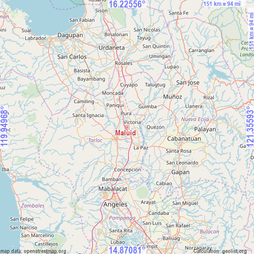
Maluid GPS coordinates[2]
15° 32' 57.48" North, 120° 39' 10.08" East
| Map corner | latitude | longitude |
|---|---|---|
| Upper-left | 16.22556°, | 119.94968° |
| Center: | 15.5493°, | 120.6528° |
| Lower-right: | 14.87081°, | 121.35593° |
| Map W x H: | 150.6×150.6 km | = 93.6×93.6mi |
| max Lat: | 20.78733° ⇑17.9% North |
| Maluid: | 15.5493° |
| min Lat: | ⇓82.1% South 4.65442° |
| min Long | Maluid | max Long |
| 117.04868° | 120.6528° | 126.58417° |
| W 13.7%⇐ | ⇒86.3% E |
Elevation
Elevation of Maluid is 34 m = 112 ft, and this is 53.9 m = 177 ft below average elevation for this country.
| Max E: |
2262 m = 7421 ft | 39.7% |
| Avg. | 87.9 m = 288 ft | |
| Maluid | 34 m = 112 ft | |
Min E: |
-2 m = -7 ft | 60.3% |
See also: Philippines elevation on elevation.city.
Geographical zone
Maluid is located in North Torrid zone (between Equator and Tropic of Cancer). Distance of this Northern Tropic circle is 877 km =544.9 mi to North.| Distance of | km | miles | from Maluid |
|---|---|---|---|
| North Pole | 8278.1 | 5143.8 | to North |
| Arctic Circle | 5672.3 | 3524.6 | to North |
| Tropic Cancer | 877 | 544.9 | to North |
| Equator | 1728.9 | 1074.3 | to South |


Nearby cities:
15 places around Maluid: (largest is in red/bold)
• Amacalan
5.7 km =3.5 mi,  308°
308°
• Bakulong
2 km =1.2 mi,  230°
230°
• Balayang
4.4 km =2.7 mi,  89°
89°
• Balingcanaway
8.2 km =5.1 mi,  154°
154°
• Bularit
3.9 km =2.4 mi,  302°
302°
• Cardona
7.2 km =4.5 mi,  290°
290°
• Estipona
4.8 km =3 mi,  340°
340°
• Matayumtayum
7.1 km =4.4 mi,  120°
120°
• San Jacinto
1.9 km =1.2 mi,  105°
105°
• San Manuel
6.7 km =4.2 mi,  168°
168°
• San Nicolas
4.6 km =2.9 mi,  33°
33°
• San Pascual
5.5 km =3.4 mi,  163°
163°
• Sinait
7.4 km =4.6 mi,  259°
259°
• Tariji
5.2 km =3.2 mi, 232°
• Victoria
4.4 km =2.7 mi,  45°
45°
Sources, notices
• [Note1] Compared only with cities in Philippines existing in our database
• [Src1] Map data: © OpenStreetMap contributors (CC-BY-SA)
• [Src2] Other city data from geonames.org with taken over terms of usage.
• [Src3] Geographical zone / Annual Mean Temperature by Robert A. Rohde @ Wikipedia
