Balayang geodata
Balayang (Central Luzon) is a populated place; located in Philippines in Asia/Manila (GMT+8) time zone. With population of 2,923 people, there are 2619 cities with bigger population in this country. Compared to other cities in Philippines, 82.2% of cities are located further ↓South; 85.1% of cities are located further →East and 56.6% of cities have lower elevation than Balayang. Note1


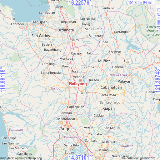
Balayang GPS coordinates[2]
15° 32' 58.2" North, 120° 41' 39.48" East
| Map corner | latitude | longitude |
|---|---|---|
| Upper-left | 16.22576°, | 119.99118° |
| Center: | 15.5495°, | 120.6943° |
| Lower-right: | 14.87101°, | 121.39743° |
| Map W x H: | 150.6×150.6 km | = 93.6×93.6mi |
| max Lat: | 20.78733° ⇑17.8% North |
| Balayang: | 15.5495° |
| min Lat: | ⇓82.2% South 4.65442° |
| min Long | Balayang | max Long |
| 117.04868° | 120.6943° | 126.58417° |
| W 14.9%⇐ | ⇒85.1% E |
Elevation
Elevation of Balayang is 29 m = 95 ft, and this is 58.9 m = 193 ft below average elevation for this country.
| Max E: |
2262 m = 7421 ft | 43.4% |
| Avg. | 87.9 m = 288 ft | |
| Balayang | 29 m = 95 ft | |
Min E: |
-2 m = -7 ft | 56.6% |
See also: Philippines elevation on elevation.city.
Geographical zone
Balayang is located in North Torrid zone (between Equator and Tropic of Cancer). Distance of this Northern Tropic circle is 877 km =544.9 mi to North.| Distance of | km | miles | from Balayang |
|---|---|---|---|
| North Pole | 8278.1 | 5143.8 | to North |
| Arctic Circle | 5672.2 | 3524.5 | to North |
| Tropic Cancer | 877 | 544.9 | to North |
| Equator | 1728.9 | 1074.3 | to South |


Nearby cities:
15 places around Balayang: (largest is in red/bold)
• Bakulong
6.1 km =3.8 mi,  257°
257°
• Balingcanaway
7.5 km =4.7 mi,  187°
187°
• Bundoc
7.5 km =4.7 mi,  160°
160°
• Calibungan
6.3 km =3.9 mi,  30°
30°
• Estipona
7.6 km =4.7 mi,  306°
306°
• Licab
7.4 km =4.6 mi,  94°
94°
• Lomboy
6.8 km =4.2 mi, 158°
• Maluid
4.4 km =2.7 mi,  269°
269°
• Matayumtayum
4 km =2.5 mi, 155°
• San Jacinto
2.7 km =1.7 mi, 259°
• San Manuel
7.2 km =4.5 mi,  205°
205°
• San Nicolas
4.3 km =2.7 mi,  333°
333°
• San Pascual
6.1 km =3.8 mi, 208°
• Victoria
3.4 km =2.1 mi,  337°
337°
• Villarosa
6 km =3.7 mi, 89°
Sources, notices
• [Note1] Compared only with cities in Philippines existing in our database
• [Src1] Map data: © OpenStreetMap contributors (CC-BY-SA)
• [Src2] Other city data from geonames.org with taken over terms of usage.
• [Src3] Geographical zone / Annual Mean Temperature by Robert A. Rohde @ Wikipedia
