Rapu-Rapu geodata
Rapu-Rapu (Bicol) is a seat of a third-order administrative division; located in Philippines in Asia/Manila (GMT+8) time zone. With population of 4,647 people, there are 1431 cities with bigger population in this country. Compared to other cities in Philippines, 58.8% of cities are located further ↓South; 73.2% of cities are located further ←West and 97.1% of cities have higher elevation than Rapu-Rapu. Note1


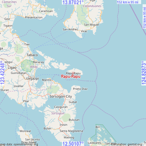
Rapu-Rapu GPS coordinates[2]
13° 11' 11.76" North, 124° 7' 32.16" East
| Map corner | latitude | longitude |
|---|---|---|
| Upper-left | 13.87021°, | 123.42248° |
| Center: | 13.1866°, | 124.1256° |
| Lower-right: | 12.50107°, | 124.82873° |
| Map W x H: | 152.2×152.2 km | = 94.6×94.6mi |
| max Lat: | 20.78733° ⇑41.2% North |
| Rapu-Rapu: | 13.1866° |
| min Lat: | ⇓58.8% South 4.65442° |
| min Long | Rapu-Rapu | max Long |
| 117.04868° | 124.1256° | 126.58417° |
| W 73.2%⇐ | ⇒26.8% E |
Elevation
Elevation of Rapu-Rapu is 4 m = 13 ft, and this is 83.9 m = 275 ft below average elevation for this country.
| Max E: |
2262 m = 7421 ft | 97.1% |
| Avg. | 87.9 m = 288 ft | |
| Rapu-Rapu | 4 m = 13 ft | |
Min E: |
-2 m = -7 ft | 2.9% |
See also: Philippines elevation on elevation.city.
Geographical zone
Rapu-Rapu is located in North Torrid zone (between Equator and Tropic of Cancer). Distance of this Northern Tropic circle is 1139.7 km =708.2 mi to North.| Distance of | km | miles | from Rapu-Rapu |
|---|---|---|---|
| North Pole | 8540.8 | 5307 | to North |
| Arctic Circle | 5935 | 3687.8 | to North |
| Tropic Cancer | 1139.7 | 708.2 | to North |
| Equator | 1466.2 | 911.1 | to South |


Nearby cities:
15 places around Rapu-Rapu: (largest is in red/bold)
• Abuyog
27.9 km =17.3 mi,  196°
196°
• Bacon
18.9 km =11.7 mi,  208°
208°
• Bagacay
22.8 km =14.2 mi,  175°
175°
• Balete
21.2 km =13.2 mi, 208°
• Basud
29.1 km =18.1 mi,  220°
220°
• Buhatan
24.9 km =15.5 mi, 199°
• Carriedo
28.1 km =17.5 mi, 184°
• Gabao
24.6 km =15.3 mi, 208°
• Manito
28.6 km =17.8 mi,  255°
255°
• Osiao
18.9 km =11.7 mi,  235°
235°
• Pawa
26 km =16.2 mi, 256°
• Prieto Diaz
17.7 km =11 mi,  155°
155°
• Santo Niño
19.3 km =12 mi, 241°
• Sorsogon
27.7 km =17.2 mi, 211°
• Sugod
22.7 km =14.1 mi,  192°
192°
Sources, notices
• [Note1] Compared only with cities in Philippines existing in our database
• [Src1] Map data: © OpenStreetMap contributors (CC-BY-SA)
• [Src2] Other city data from geonames.org with taken over terms of usage.
• [Src3] Geographical zone / Annual Mean Temperature by Robert A. Rohde @ Wikipedia
