Pulong Gubat geodata
Pulong Gubat (Central Luzon) is a populated place; located in Philippines in Asia/Manila (GMT+8) time zone. With population of 4,697 people, there are 1415 cities with bigger population in this country. Compared to other cities in Philippines, 76.1% of cities are located further ↓South; 79.2% of cities are located further →East and 70.2% of cities have higher elevation than Pulong Gubat. Note1
Administrative division(s):
- Level 1: Central Luzon
- Level 2: Province of Bulacan
- Level 3: Balagtas (Bigaa)


Pulong Gubat GPS coordinates[2]
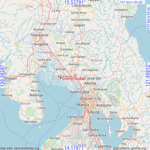
14° 51' 33.768" North, 120° 54' 21.564" East
| Map corner | latitude | longitude |
|---|---|---|
| Upper-left | 15.53791°, | 120.20287° |
| Center: | 14.85938°, | 120.90599° |
| Lower-right: | 14.17871°, | 121.60912° |
| Map W x H: | 151.1×151.1 km | = 93.9×93.9mi |
| max Lat: | 20.78733° ⇑23.9% North |
| Pulong Gubat: | 14.85938° |
| min Lat: | ⇓76.1% South 4.65442° |
| min Long | Pulong Gubat | max Long |
| 117.04868° | 120.90599° | 126.58417° |
| W 20.8%⇐ | ⇒79.2% E |
Elevation
Elevation of Pulong Gubat is 12 m = 39 ft, and this is 75.9 m = 249 ft below average elevation for this country.
| Max E: |
2262 m = 7421 ft | 70.2% |
| Avg. | 87.9 m = 288 ft | |
| Pulong Gubat | 12 m = 39 ft | |
Min E: |
-2 m = -7 ft | 29.8% |
See also: Philippines elevation on elevation.city.
Geographical zone
Pulong Gubat is located in North Torrid zone (between Equator and Tropic of Cancer). Distance of this Northern Tropic circle is 953.7 km =592.6 mi to North.| Distance of | km | miles | from Pulong Gubat |
|---|---|---|---|
| North Pole | 8354.9 | 5191.5 | to North |
| Arctic Circle | 5749 | 3572.3 | to North |
| Tropic Cancer | 953.7 | 592.6 | to North |
| Equator | 1652.2 | 1026.6 | to South |


Nearby cities:
15 places around Pulong Gubat: (largest is in red/bold)
• Angat
8 km =5 mi,  201°
201°
• Bagong Barrio
5.1 km =3.2 mi,  47°
47°
• Balagtas
6.4 km =4 mi,  221°
221°
• Bocaue
7.1 km =4.4 mi,  162°
162°
• Bulihan
2.1 km =1.3 mi,  328°
328°
• Culianin
6.2 km =3.9 mi,  352°
352°
• Guiguinto
3.8 km =2.4 mi, 220°
• Guyong
8.2 km =5.1 mi,  108°
108°
• Liciada
6.8 km =4.2 mi,  24°
24°
• Manatal
2.2 km =1.4 mi,  29°
29°
• Pandi
5.5 km =3.4 mi,  83°
83°
• Plaridel
6.1 km =3.8 mi,  300°
300°
• Pulilan
7.7 km =4.8 mi,  307°
307°
• Santa Maria
7.5 km =4.7 mi,  124°
124°
• Sulucan
7.5 km =4.7 mi, 163°
Sources, notices
• [Note1] Compared only with cities in Philippines existing in our database
• [Src1] Map data: © OpenStreetMap contributors (CC-BY-SA)
• [Src2] Other city data from geonames.org with taken over terms of usage.
• [Src3] Geographical zone / Annual Mean Temperature by Robert A. Rohde @ Wikipedia
