Guyong geodata
Guyong (Central Luzon) is a populated place; located in Philippines in Asia/Manila (GMT+8) time zone. With population of 155,391 people, there are 65 cities with bigger population in this country. Compared to other cities in Philippines, 76% of cities are located further ↓South; 76.8% of cities are located further →East and 65.2% of cities have lower elevation than Guyong. Note1
Administrative division(s):
- Level 1: Central Luzon
- Level 2: Province of Bulacan
- Level 3: Santa Maria


Guyong GPS coordinates[2]
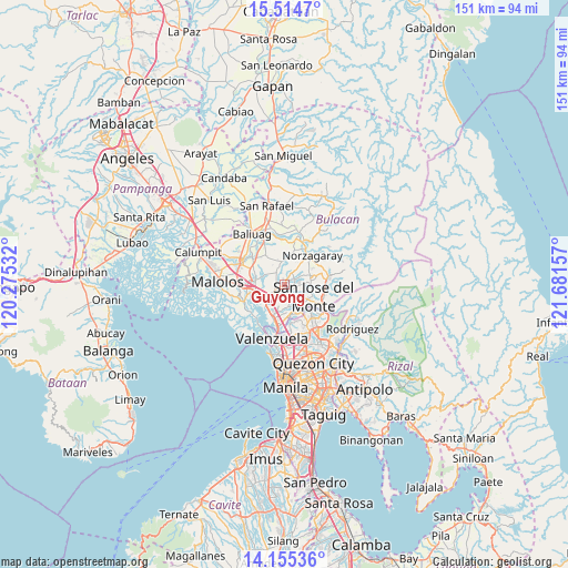
14° 50' 9.96" North, 120° 58' 42.384" East
| Map corner | latitude | longitude |
|---|---|---|
| Upper-left | 15.5147°, | 120.27532° |
| Center: | 14.8361°, | 120.97844° |
| Lower-right: | 14.15536°, | 121.68157° |
| Map W x H: | 151.1×151.1 km | = 93.9×93.9mi |
| max Lat: | 20.78733° ⇑24% North |
| Guyong: | 14.8361° |
| min Lat: | ⇓76% South 4.65442° |
| min Long | Guyong | max Long |
| 117.04868° | 120.97844° | 126.58417° |
| W 23.2%⇐ | ⇒76.8% E |
Elevation
Elevation of Guyong is 42 m = 138 ft, and this is 45.9 m = 151 ft below average elevation for this country.
| Max E: |
2262 m = 7421 ft | 34.8% |
| Avg. | 87.9 m = 288 ft | |
| Guyong | 42 m = 138 ft | |
Min E: |
-2 m = -7 ft | 65.2% |
See also: Guyong elevation on elevation.city.
Geographical zone
Guyong is located in North Torrid zone (between Equator and Tropic of Cancer). Distance of this Northern Tropic circle is 956.3 km =594.2 mi to North.| Distance of | km | miles | from Guyong |
|---|---|---|---|
| North Pole | 8357.4 | 5193 | to North |
| Arctic Circle | 5751.6 | 3573.9 | to North |
| Tropic Cancer | 956.3 | 594.2 | to North |
| Equator | 1649.6 | 1025 | to South |


Nearby cities:
15 places around Guyong: (largest is in red/bold)
• Bagong Barrio
7.2 km =4.5 mi,  326°
326°
• Balasing
4.2 km =2.6 mi,  60°
60°
• Bituñgol
7.9 km =4.9 mi,  48°
48°
• Bocaue
7 km =4.3 mi,  233°
233°
• Bulihan
9.9 km =6.2 mi,  296°
296°
• Guiguinto
10.2 km =6.3 mi,  268°
268°
• Liciada
10.1 km =6.3 mi, 330°
• Loma de Gato
5.7 km =3.5 mi,  157°
157°
• Manatal
8.1 km =5 mi, 304°
• Marilao
9.3 km =5.8 mi,  200°
200°
• Pandi
3.9 km =2.4 mi,  324°
324°
• Pulong Gubat
8.2 km =5.1 mi,  288°
288°
• San Jose del Monte
7.6 km =4.7 mi,  108°
108°
• Santa Maria
2.3 km =1.4 mi,  223°
223°
• Sulucan
7.3 km =4.5 mi, 230°
Sources, notices
• [Note1] Compared only with cities in Philippines existing in our database
• [Src1] Map data: © OpenStreetMap contributors (CC-BY-SA)
• [Src2] Other city data from geonames.org with taken over terms of usage.
• [Src3] Geographical zone / Annual Mean Temperature by Robert A. Rohde @ Wikipedia
