Pandi geodata
Pandi (Central Luzon) is a seat of a third-order administrative division; located in Philippines in Asia/Manila (GMT+8) time zone. With population of 34,927 people, there are 242 cities with bigger population in this country. Compared to other cities in Philippines, 76.1% of cities are located further ↓South; 77.5% of cities are located further →East and 64.7% of cities have lower elevation than Pandi. Note1


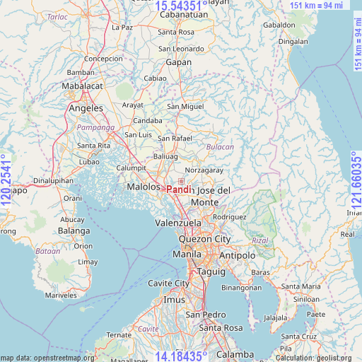
Pandi GPS coordinates[2]
14° 51' 54" North, 120° 57' 25.992" East
| Map corner | latitude | longitude |
|---|---|---|
| Upper-left | 15.54351°, | 120.2541° |
| Center: | 14.865°, | 120.95722° |
| Lower-right: | 14.18435°, | 121.66035° |
| Map W x H: | 151.1×151.1 km | = 93.9×93.9mi |
| max Lat: | 20.78733° ⇑23.9% North |
| Pandi: | 14.865° |
| min Lat: | ⇓76.1% South 4.65442° |
| min Long | Pandi | max Long |
| 117.04868° | 120.95722° | 126.58417° |
| W 22.5%⇐ | ⇒77.5% E |
Elevation
Elevation of Pandi is 41 m = 135 ft, and this is 46.9 m = 154 ft below average elevation for this country.
| Max E: |
2262 m = 7421 ft | 35.3% |
| Avg. | 87.9 m = 288 ft | |
| Pandi | 41 m = 135 ft | |
Min E: |
-2 m = -7 ft | 64.7% |
See also: Philippines elevation on elevation.city.
Geographical zone
Pandi is located in North Torrid zone (between Equator and Tropic of Cancer). Distance of this Northern Tropic circle is 953.1 km =592.2 mi to North.| Distance of | km | miles | from Pandi |
|---|---|---|---|
| North Pole | 8354.2 | 5191.1 | to North |
| Arctic Circle | 5748.3 | 3571.8 | to North |
| Tropic Cancer | 953.1 | 592.2 | to North |
| Equator | 1652.8 | 1027 | to South |


Nearby cities:
15 places around Pandi: (largest is in red/bold)
• Bagong Barrio
3.3 km =2.1 mi,  327°
327°
• Balasing
6.1 km =3.8 mi,  101°
101°
• Bituñgol
8.4 km =5.2 mi,  76°
76°
• Bocaue
8.1 km =5 mi,  204°
204°
• Bulihan
6.7 km =4.2 mi,  280°
280°
• Culianin
8.4 km =5.2 mi,  311°
311°
• Guiguinto
8.7 km =5.4 mi,  246°
246°
• Guyong
3.9 km =2.4 mi,  144°
144°
• Liciada
6.2 km =3.9 mi, 333°
• Manatal
4.6 km =2.9 mi,  286°
286°
• Niugan
9.1 km =5.7 mi,  6°
6°
• Pulong Gubat
5.5 km =3.4 mi,  263°
263°
• San Rafael
9.3 km =5.8 mi,  3°
3°
• Santa Maria
5 km =3.1 mi,  172°
172°
• Sulucan
8.5 km =5.3 mi, 203°
Sources, notices
• [Note1] Compared only with cities in Philippines existing in our database
• [Src1] Map data: © OpenStreetMap contributors (CC-BY-SA)
• [Src2] Other city data from geonames.org with taken over terms of usage.
• [Src3] Geographical zone / Annual Mean Temperature by Robert A. Rohde @ Wikipedia
