Bulihan geodata
Bulihan (Central Luzon) is a populated place; located in Philippines in Asia/Manila (GMT+8) time zone. With population of 4,869 people, there are 1351 cities with bigger population in this country. Compared to other cities in Philippines, 76.2% of cities are located further ↓South; 79.6% of cities are located further →East and 67.4% of cities have higher elevation than Bulihan. Note1


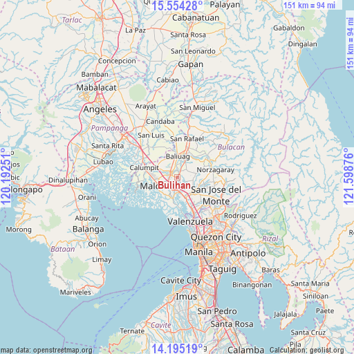
Bulihan GPS coordinates[2]
14° 52' 32.916" North, 120° 53' 44.268" East
| Map corner | latitude | longitude |
|---|---|---|
| Upper-left | 15.55428°, | 120.19251° |
| Center: | 14.87581°, | 120.89563° |
| Lower-right: | 14.19519°, | 121.59876° |
| Map W x H: | 151.1×151.1 km | = 93.9×93.9mi |
| max Lat: | 20.78733° ⇑23.8% North |
| Bulihan: | 14.87581° |
| min Lat: | ⇓76.2% South 4.65442° |
| min Long | Bulihan | max Long |
| 117.04868° | 120.89563° | 126.58417° |
| W 20.4%⇐ | ⇒79.6% E |
Elevation
Elevation of Bulihan is 13 m = 43 ft, and this is 74.9 m = 246 ft below average elevation for this country.
| Max E: |
2262 m = 7421 ft | 67.4% |
| Avg. | 87.9 m = 288 ft | |
| Bulihan | 13 m = 43 ft | |
Min E: |
-2 m = -7 ft | 32.6% |
See also: Philippines elevation on elevation.city.
Geographical zone
Bulihan is located in North Torrid zone (between Equator and Tropic of Cancer). Distance of this Northern Tropic circle is 951.9 km =591.5 mi to North.| Distance of | km | miles | from Bulihan |
|---|---|---|---|
| North Pole | 8353 | 5190.3 | to North |
| Arctic Circle | 5747.1 | 3571.1 | to North |
| Tropic Cancer | 951.9 | 591.5 | to North |
| Equator | 1654 | 1027.7 | to South |


Nearby cities:
15 places around Bulihan: (largest is in red/bold)
• Angat
9.4 km =5.8 mi,  191°
191°
• Bagong Barrio
5.1 km =3.2 mi,  72°
72°
• Balagtas
7.3 km =4.5 mi,  205°
205°
• Baliuag
8.8 km =5.5 mi,  0°
0°
• Bocaue
9.2 km =5.7 mi,  159°
159°
• Bustos
9.4 km =5.8 mi,  14°
14°
• Culianin
4.4 km =2.7 mi, 3°
• Dampol
8.4 km =5.2 mi,  289°
289°
• Guiguinto
4.9 km =3 mi,  195°
195°
• Liciada
5.8 km =3.6 mi,  41°
41°
• Manatal
2.2 km =1.4 mi,  86°
86°
• Pandi
6.7 km =4.2 mi,  100°
100°
• Plaridel
4.3 km =2.7 mi, 287°
• Pulilan
5.8 km =3.6 mi,  299°
299°
• Pulong Gubat
2.1 km =1.3 mi,  148°
148°
Sources, notices
• [Note1] Compared only with cities in Philippines existing in our database
• [Src1] Map data: © OpenStreetMap contributors (CC-BY-SA)
• [Src2] Other city data from geonames.org with taken over terms of usage.
• [Src3] Geographical zone / Annual Mean Temperature by Robert A. Rohde @ Wikipedia
