Liciada geodata
Liciada (Central Luzon) is a populated place; located in Philippines in Asia/Manila (GMT+8) time zone. With population of 3,982 people, there are 1739 cities with bigger population in this country. Compared to other cities in Philippines, 76.6% of cities are located further ↓South; 78.4% of cities are located further →East and 54.4% of cities have lower elevation than Liciada. Note1


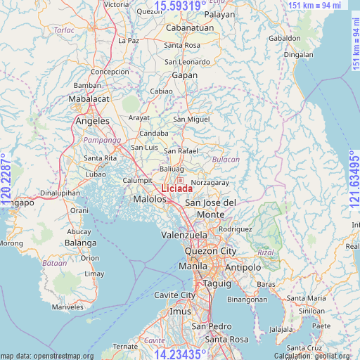
Liciada GPS coordinates[2]
14° 54' 53.424" North, 120° 55' 54.552" East
| Map corner | latitude | longitude |
|---|---|---|
| Upper-left | 15.59319°, | 120.2287° |
| Center: | 14.91484°, | 120.93182° |
| Lower-right: | 14.23435°, | 121.63495° |
| Map W x H: | 151.1×151.1 km | = 93.9×93.9mi |
| max Lat: | 20.78733° ⇑23.4% North |
| Liciada: | 14.91484° |
| min Lat: | ⇓76.6% South 4.65442° |
| min Long | Liciada | max Long |
| 117.04868° | 120.93182° | 126.58417° |
| W 21.6%⇐ | ⇒78.4% E |
Elevation
Elevation of Liciada is 27 m = 89 ft, and this is 60.9 m = 200 ft below average elevation for this country.
| Max E: |
2262 m = 7421 ft | 45.6% |
| Avg. | 87.9 m = 288 ft | |
| Liciada | 27 m = 89 ft | |
Min E: |
-2 m = -7 ft | 54.4% |
See also: Philippines elevation on elevation.city.
Geographical zone
Liciada is located in North Torrid zone (between Equator and Tropic of Cancer). Distance of this Northern Tropic circle is 947.5 km =588.7 mi to North.| Distance of | km | miles | from Liciada |
|---|---|---|---|
| North Pole | 8348.7 | 5187.6 | to North |
| Arctic Circle | 5742.8 | 3568.4 | to North |
| Tropic Cancer | 947.5 | 588.7 | to North |
| Equator | 1658.4 | 1030.5 | to South |


Nearby cities:
15 places around Liciada: (largest is in red/bold)
• Bagong Barrio
2.9 km =1.8 mi,  160°
160°
• Baliuag
5.8 km =3.6 mi,  319°
319°
• Bulihan
5.8 km =3.6 mi,  221°
221°
• Bustos
5 km =3.1 mi,  342°
342°
• Culianin
3.6 km =2.2 mi,  270°
270°
• Guyong
10.1 km =6.3 mi,  150°
150°
• Manatal
4.5 km =2.8 mi,  201°
201°
• Niugan
5.1 km =3.2 mi,  47°
47°
• Pandi
6.2 km =3.9 mi, 153°
• Pantubig
6.4 km =4 mi,  22°
22°
• Plaridel
8.6 km =5.3 mi,  249°
249°
• Pulilan
9 km =5.6 mi,  260°
260°
• Pulo
10.3 km =6.4 mi,  59°
59°
• Pulong Gubat
6.8 km =4.2 mi, 204°
• San Rafael
5 km =3.1 mi,  41°
41°
Sources, notices
• [Note1] Compared only with cities in Philippines existing in our database
• [Src1] Map data: © OpenStreetMap contributors (CC-BY-SA)
• [Src2] Other city data from geonames.org with taken over terms of usage.
• [Src3] Geographical zone / Annual Mean Temperature by Robert A. Rohde @ Wikipedia
