Tapia geodata
Tapia (Davao) is a populated place; located in Philippines in Asia/Manila (GMT+8) time zone. With population of 2,720 people, there are 2911 cities with bigger population in this country. Compared to other cities in Philippines, 84.7% of cities are located further ↑North; 97.8% of cities are located further ←West and 76% of cities have lower elevation than Tapia. Note1


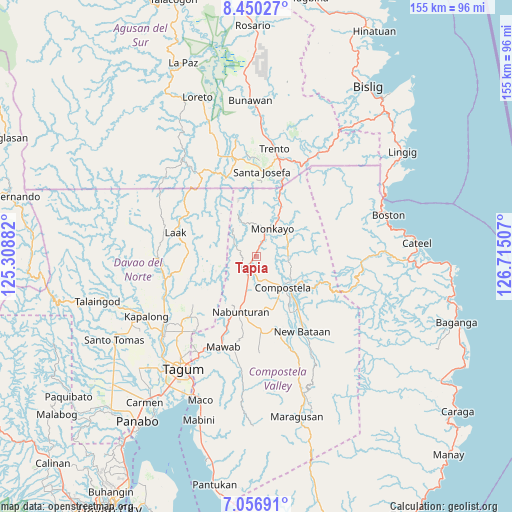
Tapia GPS coordinates[2]
7° 45' 15.012" North, 126° 0' 42.984" East
| Map corner | latitude | longitude |
|---|---|---|
| Upper-left | 8.45027°, | 125.30882° |
| Center: | 7.75417°, | 126.01194° |
| Lower-right: | 7.05691°, | 126.71507° |
| Map W x H: | 154.9×154.9 km | = 96.3×96.3mi |
| max Lat: | 20.78733° ⇑84.7% North |
| Tapia: | 7.75417° |
| min Lat: | ⇓15.3% South 4.65442° |
| min Long | Tapia | max Long |
| 117.04868° | 126.01194° | 126.58417° |
| W 97.8%⇐ | ⇒2.2% E |
Elevation
Elevation of Tapia is 72 m = 236 ft, and this is 15.9 m = 52 ft below average elevation for this country.
| Max E: |
2262 m = 7421 ft | 24% |
| Avg. | 87.9 m = 288 ft | |
| Tapia | 72 m = 236 ft | |
Min E: |
-2 m = -7 ft | 76% |
See also: Philippines elevation on elevation.city.
Geographical zone
Tapia is located in North Torrid zone (between Equator and Tropic of Cancer). Distance of Equator is 862.2 km =535.7 mi to South.| Distance of | km | miles | from Tapia |
|---|---|---|---|
| North Pole | 9144.9 | 5682.4 | to North |
| Arctic Circle | 6539 | 4063.1 | to North |
| Tropic Cancer | 1743.7 | 1083.5 | to North |
| Equator | 862.2 | 535.7 | to South |


Nearby cities:
15 places around Tapia: (largest is in red/bold)
• Babag
6.9 km =4.3 mi,  109°
109°
• Bantacan
21.2 km =13.2 mi,  142°
142°
• Baylo
12.2 km =7.6 mi,  23°
23°
• Cabinuangan
8.2 km =5.1 mi,  163°
163°
• Compostela
12.4 km =7.7 mi, 136°
• Gabi
17.2 km =10.7 mi,  149°
149°
• Kaligutan
22.6 km =14 mi,  255°
255°
• Linoan
14.8 km =9.2 mi,  196°
196°
• Manat
21.2 km =13.2 mi,  178°
178°
• Mawab
21.1 km =13.1 mi,  188°
188°
• Monkayo
8.3 km =5.2 mi,  34°
34°
• Montevista
7.2 km =4.5 mi, 200°
• Nabunturan
17 km =10.6 mi, 197°
• Pasian
20.3 km =12.6 mi, 17°
• San Vicente
23.2 km =14.4 mi,  292°
292°
Sources, notices
• [Note1] Compared only with cities in Philippines existing in our database
• [Src1] Map data: © OpenStreetMap contributors (CC-BY-SA)
• [Src2] Other city data from geonames.org with taken over terms of usage.
• [Src3] Geographical zone / Annual Mean Temperature by Robert A. Rohde @ Wikipedia
