Montevista geodata
Montevista (Davao) is a seat of a third-order administrative division; located in Philippines in Asia/Manila (GMT+8) time zone. With population of 10,147 people, there are 602 cities with bigger population in this country. Compared to other cities in Philippines, 85.2% of cities are located further ↑North; 97.6% of cities are located further ←West and 76.2% of cities have lower elevation than Montevista. Note1


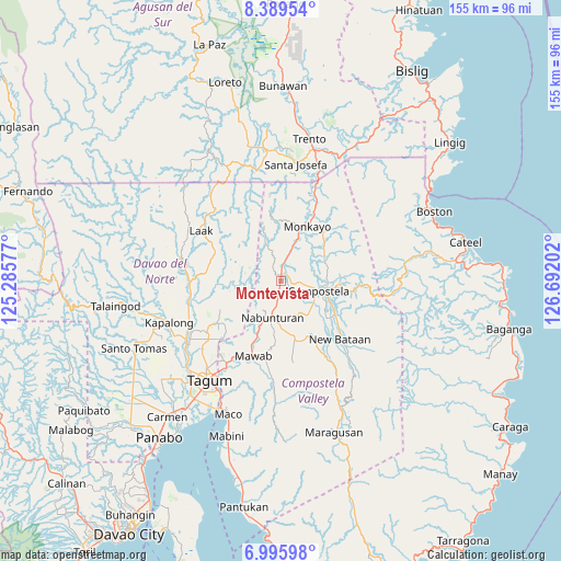
Montevista GPS coordinates[2]
7° 41' 35.988" North, 125° 59' 20.004" East
| Map corner | latitude | longitude |
|---|---|---|
| Upper-left | 8.38954°, | 125.28577° |
| Center: | 7.69333°, | 125.98889° |
| Lower-right: | 6.99598°, | 126.69202° |
| Map W x H: | 154.9×155 km | = 96.3×96.3mi |
| max Lat: | 20.78733° ⇑85.2% North |
| Montevista: | 7.69333° |
| min Lat: | ⇓14.8% South 4.65442° |
| min Long | Montevista | max Long |
| 117.04868° | 125.98889° | 126.58417° |
| W 97.6%⇐ | ⇒2.4% E |
Elevation
Elevation of Montevista is 73 m = 240 ft, and this is 14.9 m = 49 ft below average elevation for this country.
| Max E: |
2262 m = 7421 ft | 23.8% |
| Avg. | 87.9 m = 288 ft | |
| Montevista | 73 m = 240 ft | |
Min E: |
-2 m = -7 ft | 76.2% |
See also: Philippines elevation on elevation.city.
Geographical zone
Montevista is located in North Torrid zone (between Equator and Tropic of Cancer). Distance of Equator is 855.4 km =531.5 mi to South.| Distance of | km | miles | from Montevista |
|---|---|---|---|
| North Pole | 9151.6 | 5686.5 | to North |
| Arctic Circle | 6545.8 | 4067.4 | to North |
| Tropic Cancer | 1750.5 | 1087.7 | to North |
| Equator | 855.4 | 531.5 | to South |


Nearby cities:
15 places around Montevista: (largest is in red/bold)
• Babag
10.1 km =6.3 mi,  64°
64°
• Bantacan
18.4 km =11.4 mi,  122°
122°
• Baylo
19.4 km =12.1 mi,  22°
22°
• Cabinuangan
5 km =3.1 mi,  102°
102°
• Compostela
11.2 km =7 mi, 101°
• Gabi
13.9 km =8.6 mi,  125°
125°
• Kaligutan
19.4 km =12.1 mi,  273°
273°
• Linoan
7.7 km =4.8 mi,  192°
192°
• Manat
14.8 km =9.2 mi,  167°
167°
• Manat
18.1 km =11.2 mi, 170°
• Mawab
14.1 km =8.8 mi,  182°
182°
• Monkayo
15.4 km =9.6 mi,  28°
28°
• Nabunturan
9.8 km =6.1 mi, 194°
• New Sibonga
16.1 km =10 mi,  203°
203°
• Tapia
7.2 km =4.5 mi, 20°
Sources, notices
• [Note1] Compared only with cities in Philippines existing in our database
• [Src1] Map data: © OpenStreetMap contributors (CC-BY-SA)
• [Src2] Other city data from geonames.org with taken over terms of usage.
• [Src3] Geographical zone / Annual Mean Temperature by Robert A. Rohde @ Wikipedia
