Cagayan de Oro geodata
Cagayan de Oro (Northern Mindanao) is a seat of a second-order administrative division; located in Philippines in Asia/Manila (GMT+8) time zone. With population of 445,103 people, there are 16 cities with bigger population in this country. Compared to other cities in Philippines, 78.9% of cities are located further ↑North; 81.6% of cities are located further ←West and 85.4% of cities have higher elevation than Cagayan de Oro. Note1
Administrative division(s):
- Level 1: Northern Mindanao
- Level 2: Province of Misamis Oriental
- Level 3: Cagayan De Oro City


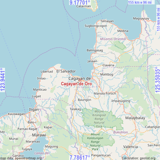
Cagayan de Oro GPS coordinates[2]
8° 28' 55.992" North, 124° 38' 49.992" East
| Map corner | latitude | longitude |
|---|---|---|
| Upper-left | 9.17701°, | 123.9441° |
| Center: | 8.48222°, | 124.64722° |
| Lower-right: | 7.78617°, | 125.35035° |
| Map W x H: | 154.6×154.6 km | = 96.1×96.1mi |
| max Lat: | 20.78733° ⇑78.9% North |
| Cagayan de Oro: | 8.48222° |
| min Lat: | ⇓21.1% South 4.65442° |
| min Long | Cagayan de Oro | max Long |
| 117.04868° | 124.64722° | 126.58417° |
| W 81.6%⇐ | ⇒18.4% E |
Elevation
Elevation of Cagayan de Oro is 8 m = 26 ft, and this is 79.9 m = 262 ft below average elevation for this country.
| Max E: |
2262 m = 7421 ft | 85.4% |
| Avg. | 87.9 m = 288 ft | |
| Cagayan de Oro | 8 m = 26 ft | |
Min E: |
-2 m = -7 ft | 14.6% |
See also: Cagayan de Oro elevation on elevation.city.
Geographical zone
Cagayan de Oro is located in North Torrid zone (between Equator and Tropic of Cancer). Distance of Equator is 943.1 km =586 mi to South.| Distance of | km | miles | from Cagayan de Oro |
|---|---|---|---|
| North Pole | 9063.9 | 5632 | to North |
| Arctic Circle | 6458 | 4012.8 | to North |
| Tropic Cancer | 1662.8 | 1033.2 | to North |
| Equator | 943.1 | 586 | to South |


Nearby cities:
15 places around Cagayan de Oro: (largest is in red/bold)
• Agusan
9.9 km =6.2 mi,  84°
84°
• Baikingon
10.4 km =6.5 mi,  263°
263°
• Barra
5.6 km =3.5 mi,  303°
303°
• Bolo Bolo
15.4 km =9.6 mi, 303°
• Bugo
12.7 km =7.9 mi, 76°
• Igpit
7.4 km =4.6 mi, 295°
• Liboran
14.2 km =8.8 mi,  179°
179°
• Lumbia
11.3 km =7 mi,  211°
211°
• Molugan
11.2 km =7 mi, 303°
• Opol
9.4 km =5.8 mi, 297°
• San Martin
16.2 km =10.1 mi,  57°
57°
• Santa Ana
15.5 km =9.6 mi, 75°
• Tagoloan
13.4 km =8.3 mi, 61°
• Taypano
15.7 km =9.8 mi,  217°
217°
• Taytay
13.5 km =8.4 mi, 298°
In other languages:
- In Spanish: Cagayán de Oro
- In France: Cagayán de Oro
- In Russian: Кагаян-де-Оро
- In Chinese: 卡加延德奥罗
Sources, notices
• [Note1] Compared only with cities in Philippines existing in our database
• [Src1] Map data: © OpenStreetMap contributors (CC-BY-SA)
• [Src2] Other city data from geonames.org with taken over terms of usage.
• [Src3] Geographical zone / Annual Mean Temperature by Robert A. Rohde @ Wikipedia
