New Bohol geodata
New Bohol (Davao) is a populated place; located in Philippines in Asia/Manila (GMT+8) time zone. With population of 3,749 people, there are 1882 cities with bigger population in this country. Compared to other cities in Philippines, 86.8% of cities are located further ↑North; 96.7% of cities are located further ←West and 59.5% of cities have lower elevation than New Bohol. Note1
Administrative division(s):
- Level 1: Davao
- Level 2: Province of Davao del Norte
- Level 3: New Corella


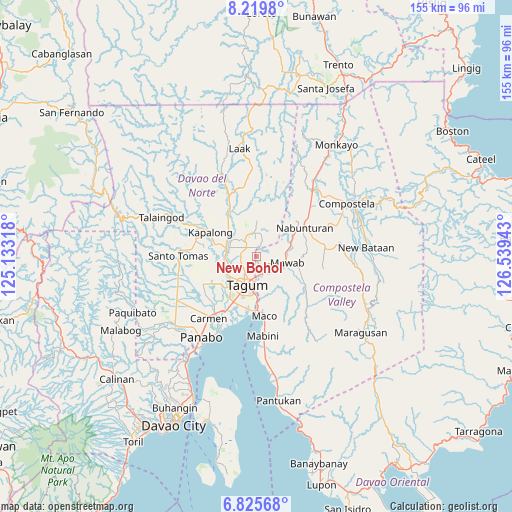
New Bohol GPS coordinates[2]
7° 31' 23.88" North, 125° 50' 10.68" East
| Map corner | latitude | longitude |
|---|---|---|
| Upper-left | 8.2198°, | 125.13318° |
| Center: | 7.5233°, | 125.8363° |
| Lower-right: | 6.82568°, | 126.53943° |
| Map W x H: | 155×155 km | = 96.3×96.3mi |
| max Lat: | 20.78733° ⇑86.8% North |
| New Bohol: | 7.5233° |
| min Lat: | ⇓13.2% South 4.65442° |
| min Long | New Bohol | max Long |
| 117.04868° | 125.8363° | 126.58417° |
| W 96.7%⇐ | ⇒3.3% E |
Elevation
Elevation of New Bohol is 33 m = 108 ft, and this is 54.9 m = 180 ft below average elevation for this country.
| Max E: |
2262 m = 7421 ft | 40.5% |
| Avg. | 87.9 m = 288 ft | |
| New Bohol | 33 m = 108 ft | |
Min E: |
-2 m = -7 ft | 59.5% |
See also: Philippines elevation on elevation.city.
Geographical zone
New Bohol is located in North Torrid zone (between Equator and Tropic of Cancer). Distance of Equator is 836.5 km =519.8 mi to South.| Distance of | km | miles | from New Bohol |
|---|---|---|---|
| North Pole | 9170.5 | 5698.3 | to North |
| Arctic Circle | 6564.7 | 4079.1 | to North |
| Tropic Cancer | 1769.4 | 1099.5 | to North |
| Equator | 836.5 | 519.8 | to South |


Nearby cities:
15 places around New Bohol: (largest is in red/bold)
• Buclad
9.5 km =5.9 mi,  273°
273°
• Cambanugoy
9.2 km =5.7 mi,  282°
282°
• Corocotan
15.4 km =9.6 mi,  207°
207°
• Del Pilar
4.5 km =2.8 mi,  346°
346°
• Dumlan
11.8 km =7.3 mi,  154°
154°
• Esperanza
12.4 km =7.7 mi,  253°
253°
• Hiju, Maco
15.4 km =9.6 mi,  183°
183°
• Limbaan
13 km =8.1 mi, 352°
• Magatos
12.6 km =7.8 mi,  286°
286°
• Magugpo Poblacion
9.1 km =5.7 mi,  202°
202°
• New Corella
7.2 km =4.5 mi, 348°
• New Leyte
9.9 km =6.2 mi, 254°
• New Sibonga
11.1 km =6.9 mi,  67°
67°
• Pagsabangan
10.7 km =6.6 mi,  243°
243°
• Talomo
12.5 km =7.8 mi, 272°
Sources, notices
• [Note1] Compared only with cities in Philippines existing in our database
• [Src1] Map data: © OpenStreetMap contributors (CC-BY-SA)
• [Src2] Other city data from geonames.org with taken over terms of usage.
• [Src3] Geographical zone / Annual Mean Temperature by Robert A. Rohde @ Wikipedia
