Limbaan geodata
Limbaan (Northern Mindanao) is a populated place; located in Philippines in Asia/Manila (GMT+8) time zone. With population of 4,855 people, there are 1357 cities with bigger population in this country. Compared to other cities in Philippines, 85.7% of cities are located further ↑North; 96.6% of cities are located further ←West and 64.1% of cities have lower elevation than Limbaan. Note1


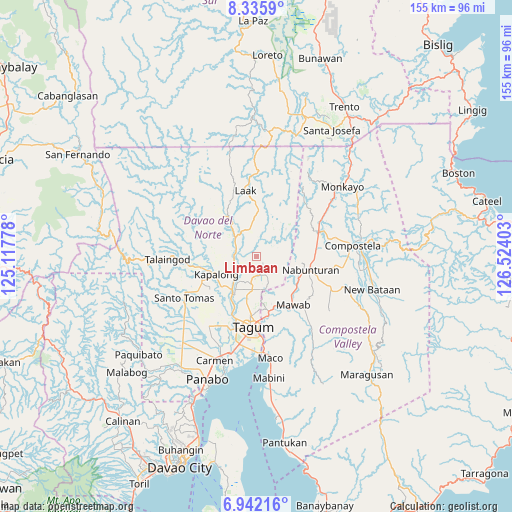
Limbaan GPS coordinates[2]
7° 38' 22.56" North, 125° 49' 15.24" East
| Map corner | latitude | longitude |
|---|---|---|
| Upper-left | 8.3359°, | 125.11778° |
| Center: | 7.6396°, | 125.8209° |
| Lower-right: | 6.94216°, | 126.52403° |
| Map W x H: | 155×155 km | = 96.3×96.3mi |
| max Lat: | 20.78733° ⇑85.7% North |
| Limbaan: | 7.6396° |
| min Lat: | ⇓14.3% South 4.65442° |
| min Long | Limbaan | max Long |
| 117.04868° | 125.8209° | 126.58417° |
| W 96.6%⇐ | ⇒3.4% E |
Elevation
Elevation of Limbaan is 40 m = 131 ft, and this is 47.9 m = 157 ft below average elevation for this country.
| Max E: |
2262 m = 7421 ft | 35.9% |
| Avg. | 87.9 m = 288 ft | |
| Limbaan | 40 m = 131 ft | |
Min E: |
-2 m = -7 ft | 64.1% |
See also: Philippines elevation on elevation.city.
Geographical zone
Limbaan is located in North Torrid zone (between Equator and Tropic of Cancer). Distance of Equator is 849.4 km =527.8 mi to South.| Distance of | km | miles | from Limbaan |
|---|---|---|---|
| North Pole | 9157.6 | 5690.3 | to North |
| Arctic Circle | 6551.7 | 4071 | to North |
| Tropic Cancer | 1756.5 | 1091.4 | to North |
| Equator | 849.4 | 527.8 | to South |


Nearby cities:
15 places around Limbaan: (largest is in red/bold)
• Buclad
14.7 km =9.1 mi,  211°
211°
• Cambanugoy
13.1 km =8.1 mi, 213°
• Concepcion
17.2 km =10.7 mi,  315°
315°
• Del Pilar
8.5 km =5.3 mi,  175°
175°
• Gabuyan
17.1 km =10.6 mi,  258°
258°
• Kaligutan
7.1 km =4.4 mi,  353°
353°
• Linoan
17 km =10.6 mi,  95°
95°
• Magatos
14 km =8.7 mi,  228°
228°
• Nabunturan
16.4 km =10.2 mi, 102°
• New Bohol
13 km =8.1 mi,  172°
172°
• New Corella
5.9 km =3.7 mi, 177°
• New Leyte
17.4 km =10.8 mi, 206°
• New Sibonga
14.9 km =9.3 mi,  126°
126°
• Pag-asa
16.7 km =10.4 mi,  244°
244°
• Talomo
16.4 km =10.2 mi,  221°
221°
Sources, notices
• [Note1] Compared only with cities in Philippines existing in our database
• [Src1] Map data: © OpenStreetMap contributors (CC-BY-SA)
• [Src2] Other city data from geonames.org with taken over terms of usage.
• [Src3] Geographical zone / Annual Mean Temperature by Robert A. Rohde @ Wikipedia
