Gabi geodata
Gabi (Davao) is a populated place; located in Philippines in Asia/Manila (GMT+8) time zone. With population of 3,939 people, there are 1764 cities with bigger population in this country. Compared to other cities in Philippines, 85.8% of cities are located further ↑North; 98.5% of cities are located further ←West and 79.5% of cities have lower elevation than Gabi. Note1


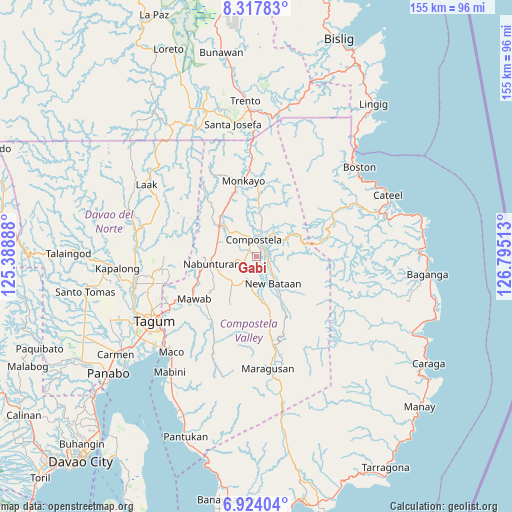
Gabi GPS coordinates[2]
7° 37' 17.4" North, 126° 5' 31.2" East
| Map corner | latitude | longitude |
|---|---|---|
| Upper-left | 8.31783°, | 125.38888° |
| Center: | 7.6215°, | 126.092° |
| Lower-right: | 6.92404°, | 126.79513° |
| Map W x H: | 155×155 km | = 96.3×96.3mi |
| max Lat: | 20.78733° ⇑85.8% North |
| Gabi: | 7.6215° |
| min Lat: | ⇓14.2% South 4.65442° |
| min Long | Gabi | max Long |
| 117.04868° | 126.092° | 126.58417° |
| W 98.5%⇐ | ⇒1.5% E |
Elevation
Elevation of Gabi is 89 m = 292 ft, and this is 1.1 m = 4 ft above average elevation for this country.
| Max E: |
2262 m = 7421 ft | 20.5% |
| Gabi | 89 m 292 ft | |
| Avg. | 87.9 m = 288 ft | |
Min E: |
-2 m = -7 ft | 79.5% |
See also: Philippines elevation on elevation.city.
Geographical zone
Gabi is located in North Torrid zone (between Equator and Tropic of Cancer). Distance of Equator is 847.4 km =526.5 mi to South.| Distance of | km | miles | from Gabi |
|---|---|---|---|
| North Pole | 9159.6 | 5691.5 | to North |
| Arctic Circle | 6553.7 | 4072.3 | to North |
| Tropic Cancer | 1758.5 | 1092.7 | to North |
| Equator | 847.4 | 526.5 | to South |


Nearby cities:
15 places around Gabi: (largest is in red/bold)
• Andili
22.3 km =13.9 mi,  217°
217°
• Babag
12.6 km =7.8 mi,  349°
349°
• Bantacan
4.6 km =2.9 mi,  115°
115°
• Cabinuangan
9.4 km =5.8 mi,  316°
316°
• Compostela
5.7 km =3.5 mi,  356°
356°
• Linoan
13 km =8.1 mi,  272°
272°
• Manat
10.3 km =6.4 mi,  231°
231°
• Manat
12.9 km =8 mi, 219°
• Mawab
13.4 km =8.3 mi,  243°
243°
• Monkayo
21.9 km =13.6 mi, 349°
• Montevista
13.9 km =8.6 mi,  305°
305°
• Nabunturan
13.9 km =8.6 mi,  263°
263°
• New Sibonga
19.1 km =11.9 mi,  249°
249°
• San Mariano
16.9 km =10.5 mi, 216°
• Tapia
17.2 km =10.7 mi,  329°
329°
Sources, notices
• [Note1] Compared only with cities in Philippines existing in our database
• [Src1] Map data: © OpenStreetMap contributors (CC-BY-SA)
• [Src2] Other city data from geonames.org with taken over terms of usage.
• [Src3] Geographical zone / Annual Mean Temperature by Robert A. Rohde @ Wikipedia
