Andili geodata
Andili (Davao) is a populated place; located in Philippines in Asia/Manila (GMT+8) time zone. With population of 4,400 people, there are 1539 cities with bigger population in this country. Compared to other cities in Philippines, 87.4% of cities are located further ↑North; 97.5% of cities are located further ←West and 82.2% of cities have lower elevation than Andili. Note1


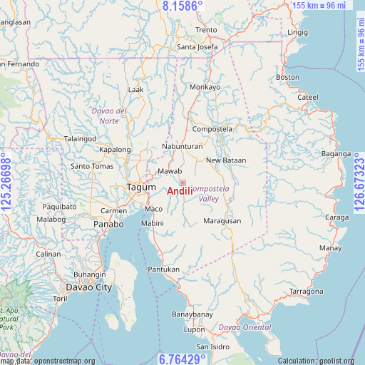
Andili GPS coordinates[2]
7° 27' 43.2" North, 125° 58' 12.36" East
| Map corner | latitude | longitude |
|---|---|---|
| Upper-left | 8.1586°, | 125.26698° |
| Center: | 7.462°, | 125.9701° |
| Lower-right: | 6.76429°, | 126.67323° |
| Map W x H: | 155×155 km | = 96.3×96.3mi |
| max Lat: | 20.78733° ⇑87.4% North |
| Andili: | 7.462° |
| min Lat: | ⇓12.6% South 4.65442° |
| min Long | Andili | max Long |
| 117.04868° | 125.9701° | 126.58417° |
| W 97.5%⇐ | ⇒2.5% E |
Elevation
Elevation of Andili is 108 m = 354 ft, and this is 20.1 m = 66 ft above average elevation for this country.
| Max E: |
2262 m = 7421 ft | 17.8% |
| Andili | 108 m 354 ft | |
| Avg. | 87.9 m = 288 ft | |
Min E: |
-2 m = -7 ft | 82.2% |
See also: Philippines elevation on elevation.city.
Geographical zone
Andili is located in North Torrid zone (between Equator and Tropic of Cancer). Distance of Equator is 829.7 km =515.6 mi to South.| Distance of | km | miles | from Andili |
|---|---|---|---|
| North Pole | 9177.4 | 5702.6 | to North |
| Arctic Circle | 6571.5 | 4083.3 | to North |
| Tropic Cancer | 1776.2 | 1103.7 | to North |
| Equator | 829.7 | 515.6 | to South |


Nearby cities:
15 places around Andili: (largest is in red/bold)
• Del Pilar
19.4 km =12.1 mi,  305°
305°
• Dumlan
10.5 km =6.5 mi,  248°
248°
• Hiju, Maco
17.8 km =11.1 mi,  241°
241°
• Linoan
18.2 km =11.3 mi,  1°
1°
• Mabini
21.2 km =13.2 mi,  217°
217°
• Maco
16.9 km =10.5 mi,  228°
228°
• Magugpo Poblacion
18.3 km =11.4 mi,  264°
264°
• Manat
9.4 km =5.8 mi,  33°
33°
• Manat
12.5 km =7.8 mi, 25°
• Mawab
11.7 km =7.3 mi,  7°
7°
• Nabunturan
16.2 km =10.1 mi,  358°
358°
• New Bohol
16.2 km =10.1 mi,  294°
294°
• New Corella
21.3 km =13.2 mi, 310°
• New Sibonga
11.9 km =7.4 mi,  338°
338°
• San Mariano
5.4 km =3.4 mi,  37°
37°
Sources, notices
• [Note1] Compared only with cities in Philippines existing in our database
• [Src1] Map data: © OpenStreetMap contributors (CC-BY-SA)
• [Src2] Other city data from geonames.org with taken over terms of usage.
• [Src3] Geographical zone / Annual Mean Temperature by Robert A. Rohde @ Wikipedia
