Manat geodata
Manat (Davao) is a populated place; located in Philippines in Asia/Manila (GMT+8) time zone. With population of 6,148 people, there are 1017 cities with bigger population in this country. Compared to other cities in Philippines, 86.6% of cities are located further ↑North; 97.9% of cities are located further ←West and 84.2% of cities have lower elevation than Manat. Note1


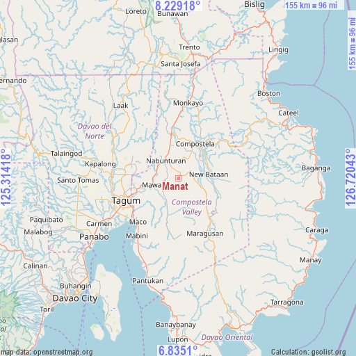
Manat GPS coordinates[2]
7° 31' 57.72" North, 126° 1' 2.28" East
| Map corner | latitude | longitude |
|---|---|---|
| Upper-left | 8.22918°, | 125.31418° |
| Center: | 7.5327°, | 126.0173° |
| Lower-right: | 6.8351°, | 126.72043° |
| Map W x H: | 155×155 km | = 96.3×96.3mi |
| max Lat: | 20.78733° ⇑86.6% North |
| Manat: | 7.5327° |
| min Lat: | ⇓13.4% South 4.65442° |
| min Long | Manat | max Long |
| 117.04868° | 126.0173° | 126.58417° |
| W 97.9%⇐ | ⇒2.1% E |
Elevation
Elevation of Manat is 126 m = 413 ft, and this is 38.1 m = 125 ft above average elevation for this country.
| Max E: |
2262 m = 7421 ft | 15.8% |
| Manat | 126 m 413 ft | |
| Avg. | 87.9 m = 288 ft | |
Min E: |
-2 m = -7 ft | 84.2% |
See also: Philippines elevation on elevation.city.
Geographical zone
Manat is located in North Torrid zone (between Equator and Tropic of Cancer). Distance of Equator is 837.6 km =520.5 mi to South.| Distance of | km | miles | from Manat |
|---|---|---|---|
| North Pole | 9169.5 | 5697.7 | to North |
| Arctic Circle | 6563.6 | 4078.4 | to North |
| Tropic Cancer | 1768.4 | 1098.8 | to North |
| Equator | 837.6 | 520.5 | to South |


Nearby cities:
15 places around Manat: (largest is in red/bold)
• Andili
9.4 km =5.8 mi,  213°
213°
• Bantacan
14.7 km =9.1 mi,  57°
57°
• Cabinuangan
16.8 km =10.4 mi,  6°
6°
• Compostela
17.5 km =10.9 mi,  26°
26°
• Del Pilar
21.3 km =13.2 mi,  279°
279°
• Dumlan
19 km =11.8 mi,  231°
231°
• Gabi
12.9 km =8 mi,  39°
39°
• Linoan
11.4 km =7.1 mi,  335°
335°
• Manat
3.4 km =2.1 mi,  2°
2°
• Mawab
5.3 km =3.3 mi,  315°
315°
• Montevista
18.1 km =11.2 mi,  350°
350°
• Nabunturan
10.1 km =6.3 mi,  326°
326°
• New Bohol
20 km =12.4 mi,  267°
267°
• New Sibonga
10.1 km =6.3 mi,  288°
288°
• San Mariano
4.1 km =2.5 mi, 207°
Sources, notices
• [Note1] Compared only with cities in Philippines existing in our database
• [Src1] Map data: © OpenStreetMap contributors (CC-BY-SA)
• [Src2] Other city data from geonames.org with taken over terms of usage.
• [Src3] Geographical zone / Annual Mean Temperature by Robert A. Rohde @ Wikipedia
