Burgos geodata
Burgos (Ilocos) is a seat of a third-order administrative division; located in Philippines in Asia/Manila (GMT+8) time zone. In our database, there are 4166 cities with bigger population. Compared to other cities in Philippines, 91% of cities are located further ↓South; 91.7% of cities are located further →East and 95.3% of cities have lower elevation than Burgos. Note1


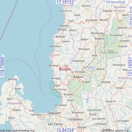
Burgos GPS coordinates[2]
16° 31' 6.996" North, 120° 27' 46.008" East
| Map corner | latitude | longitude |
|---|---|---|
| Upper-left | 17.19153°, | 119.75966° |
| Center: | 16.51861°, | 120.46278° |
| Lower-right: | 15.84334°, | 121.16591° |
| Map W x H: | 149.9×149.9 km | = 93.1×93.1mi |
| max Lat: | 20.78733° ⇑9% North |
| Burgos: | 16.51861° |
| min Lat: | ⇓91% South 4.65442° |
| min Long | Burgos | max Long |
| 117.04868° | 120.46278° | 126.58417° |
| W 8.3%⇐ | ⇒91.7% E |
Elevation
Elevation of Burgos is 441 m = 1447 ft, and this is 353.1 m = 1158 ft above average elevation for this country.
| Max E: |
2262 m = 7421 ft | 4.7% |
| Burgos | 441 m 1447 ft | |
| Avg. | 87.9 m = 288 ft | |
Min E: |
-2 m = -7 ft | 95.3% |
See also: Philippines elevation on elevation.city.
Geographical zone
Burgos is located in North Torrid zone (between Equator and Tropic of Cancer). Distance of this Northern Tropic circle is 769.2 km =478 mi to North.| Distance of | km | miles | from Burgos |
|---|---|---|---|
| North Pole | 8170.4 | 5076.8 | to North |
| Arctic Circle | 5564.5 | 3457.6 | to North |
| Tropic Cancer | 769.2 | 478 | to North |
| Equator | 1836.7 | 1141.3 | to South |


Nearby cities:
15 places around Burgos: (largest is in red/bold)
• Acao
9.2 km =5.7 mi,  274°
274°
• Bagulin
10.3 km =6.4 mi,  345°
345°
• Bauang
13.9 km =8.6 mi,  275°
275°
• Bayabas
9.6 km =6 mi,  143°
143°
• Caba
15.9 km =9.9 mi,  232°
232°
• Dagup
13.3 km =8.3 mi, 352°
• Halog West
17.6 km =10.9 mi,  196°
196°
• Kapangan
15.6 km =9.7 mi,  66°
66°
• La Trinidad
15.1 km =9.4 mi,  118°
118°
• Naguilian
7.2 km =4.5 mi, 283°
• Nangalisan
9.5 km =5.9 mi,  170°
170°
• Paringao
15.9 km =9.9 mi,  291°
291°
• Payocpoc Sur
14.6 km =9.1 mi,  259°
259°
• Sablan
4.5 km =2.8 mi,  129°
129°
• Tublay
15.9 km =9.9 mi,  80°
80°
Sources, notices
• [Note1] Compared only with cities in Philippines existing in our database
• [Src1] Map data: © OpenStreetMap contributors (CC-BY-SA)
• [Src2] Other city data from geonames.org with taken over terms of usage.
• [Src3] Geographical zone / Annual Mean Temperature by Robert A. Rohde @ Wikipedia
