Sablan geodata
Sablan (Cordillera) is a seat of a third-order administrative division; located in Philippines in Asia/Manila (GMT+8) time zone. With population of 2,456 people, there are 3369 cities with bigger population in this country. Compared to other cities in Philippines, 90.9% of cities are located further ↓South; 90.9% of cities are located further →East and 96.8% of cities have lower elevation than Sablan. Note1


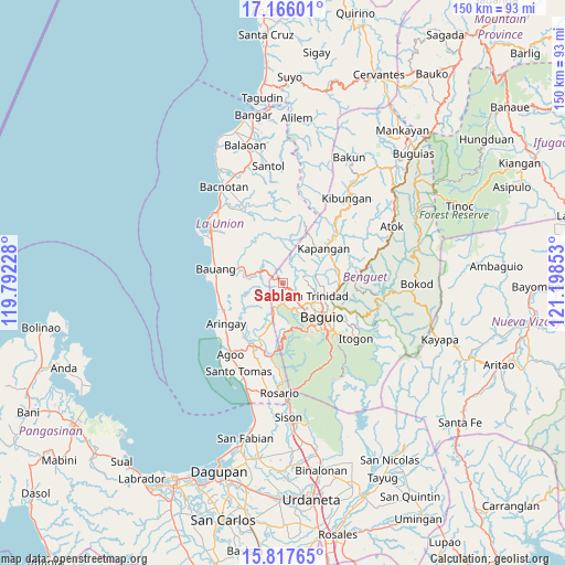
Sablan GPS coordinates[2]
16° 29' 34.8" North, 120° 29' 43.44" East
| Map corner | latitude | longitude |
|---|---|---|
| Upper-left | 17.16601°, | 119.79228° |
| Center: | 16.493°, | 120.4954° |
| Lower-right: | 15.81765°, | 121.19853° |
| Map W x H: | 149.9×149.9 km | = 93.1×93.1mi |
| max Lat: | 20.78733° ⇑9.1% North |
| Sablan: | 16.493° |
| min Lat: | ⇓90.9% South 4.65442° |
| min Long | Sablan | max Long |
| 117.04868° | 120.4954° | 126.58417° |
| W 9.1%⇐ | ⇒90.9% E |
Elevation
Elevation of Sablan is 581 m = 1906 ft, and this is 493.1 m = 1618 ft above average elevation for this country.
| Max E: |
2262 m = 7421 ft | 3.2% |
| Sablan | 581 m 1906 ft | |
| Avg. | 87.9 m = 288 ft | |
Min E: |
-2 m = -7 ft | 96.8% |
See also: Philippines elevation on elevation.city.
Geographical zone
Sablan is located in North Torrid zone (between Equator and Tropic of Cancer). Distance of this Northern Tropic circle is 772.1 km =479.8 mi to North.| Distance of | km | miles | from Sablan |
|---|---|---|---|
| North Pole | 8173.2 | 5078.6 | to North |
| Arctic Circle | 5567.3 | 3459.4 | to North |
| Tropic Cancer | 772.1 | 479.8 | to North |
| Equator | 1833.8 | 1139.5 | to South |


Nearby cities:
15 places around Sablan: (largest is in red/bold)
• Acao
13.2 km =8.2 mi,  285°
285°
• Baguio
13.5 km =8.4 mi,  129°
129°
• Bagulin
14.1 km =8.8 mi,  335°
335°
• Bayabas
5.3 km =3.3 mi,  154°
154°
• Burgos
4.5 km =2.8 mi,  309°
309°
• Caba
17.5 km =10.9 mi,  246°
246°
• Dagup
16.9 km =10.5 mi, 341°
• Halog West
16.5 km =10.3 mi,  211°
211°
• Kapangan
14.1 km =8.8 mi,  50°
50°
• La Trinidad
10.7 km =6.6 mi,  113°
113°
• Naguilian
11.5 km =7.1 mi, 293°
• Nangalisan
6.8 km =4.2 mi,  196°
196°
• Payocpoc Sur
17.8 km =11.1 mi,  270°
270°
• Taloy
17.8 km =11.1 mi,  178°
178°
• Tublay
13.4 km =8.3 mi,  65°
65°
Sources, notices
• [Note1] Compared only with cities in Philippines existing in our database
• [Src1] Map data: © OpenStreetMap contributors (CC-BY-SA)
• [Src2] Other city data from geonames.org with taken over terms of usage.
• [Src3] Geographical zone / Annual Mean Temperature by Robert A. Rohde @ Wikipedia
