Baguio geodata
Baguio (Cordillera) is a seat of a first-order administrative division; located in Philippines in Asia/Manila (GMT+8) time zone. With population of 272,714 people, there are 34 cities with bigger population in this country. Compared to other cities in Philippines, 90.6% of cities are located further ↓South; 88.4% of cities are located further →East and 99.8% of cities have lower elevation than Baguio. Note1


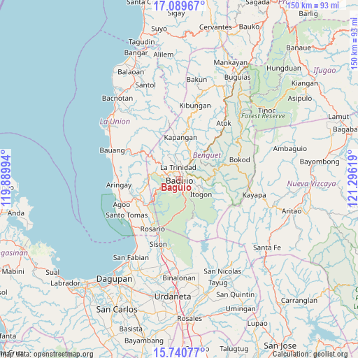
Baguio GPS coordinates[2]
16° 24' 59.004" North, 120° 35' 35.016" East
| Map corner | latitude | longitude |
|---|---|---|
| Upper-left | 17.08967°, | 119.88994° |
| Center: | 16.41639°, | 120.59306° |
| Lower-right: | 15.74077°, | 121.29619° |
| Map W x H: | 150×150 km | = 93.2×93.2mi |
| max Lat: | 20.78733° ⇑9.4% North |
| Baguio: | 16.41639° |
| min Lat: | ⇓90.6% South 4.65442° |
| min Long | Baguio | max Long |
| 117.04868° | 120.59306° | 126.58417° |
| W 11.6%⇐ | ⇒88.4% E |
Elevation
Elevation of Baguio is 1493 m = 4898 ft, and this is 1405.1 m = 4610 ft above average elevation for this country.
| Max E: |
2262 m = 7421 ft | 0.2% |
| Baguio | 1493 m 4898 ft | |
| Avg. | 87.9 m = 288 ft | |
Min E: |
-2 m = -7 ft | 99.8% |
See also: Baguio elevation on elevation.city.
Geographical zone
Baguio is located in North Torrid zone (between Equator and Tropic of Cancer). Distance of this Northern Tropic circle is 780.6 km =485 mi to North.| Distance of | km | miles | from Baguio |
|---|---|---|---|
| North Pole | 8181.7 | 5083.9 | to North |
| Arctic Circle | 5575.8 | 3464.6 | to North |
| Tropic Cancer | 780.6 | 485 | to North |
| Equator | 1825.3 | 1134.2 | to South |


Nearby cities:
15 places around Baguio: (largest is in red/bold)
• Bayabas
9 km =5.6 mi,  294°
294°
• Burgos
17.9 km =11.1 mi,  309°
309°
• Dalupirip
17.2 km =10.7 mi,  125°
125°
• Itogon
10.7 km =6.6 mi,  123°
123°
• Kapangan
17.6 km =10.9 mi,  1°
1°
• La Trinidad
4.3 km =2.7 mi,  352°
352°
• Loacan
16.8 km =10.4 mi,  27°
27°
• Nangalisan
12.5 km =7.8 mi,  279°
279°
• Pugo
17.1 km =10.6 mi,  232°
232°
• Sablan
13.5 km =8.4 mi, 309°
• Tabaan
15.3 km =9.5 mi,  212°
212°
• Taloy
13.6 km =8.5 mi, 227°
• Tuba
12 km =7.5 mi,  202°
202°
• Tublay
14.2 km =8.8 mi,  7°
7°
• Tuding
5.3 km =3.3 mi,  96°
96°
Sources, notices
• [Note1] Compared only with cities in Philippines existing in our database
• [Src1] Map data: © OpenStreetMap contributors (CC-BY-SA)
• [Src2] Other city data from geonames.org with taken over terms of usage.
• [Src3] Geographical zone / Annual Mean Temperature by Robert A. Rohde @ Wikipedia
