Sampaloc geodata
Sampaloc (Central Luzon) is a populated place; located in Philippines in Asia/Manila (GMT+8) time zone. With population of 2,206 people, there are 3880 cities with bigger population in this country. Compared to other cities in Philippines, 85% of cities are located further ↓South; 80.5% of cities are located further →East and 81.4% of cities have lower elevation than Sampaloc. Note1


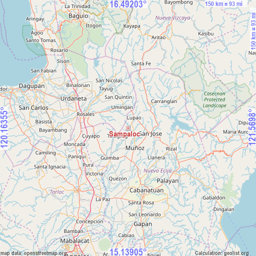
Sampaloc GPS coordinates[2]
15° 49' 0.012" North, 120° 52' 0.012" East
| Map corner | latitude | longitude |
|---|---|---|
| Upper-left | 16.49203°, | 120.16355° |
| Center: | 15.81667°, | 120.86667° |
| Lower-right: | 15.13905°, | 121.5698° |
| Map W x H: | 150.4×150.4 km | = 93.5×93.5mi |
| max Lat: | 20.78733° ⇑15% North |
| Sampaloc: | 15.81667° |
| min Lat: | ⇓85% South 4.65442° |
| min Long | Sampaloc | max Long |
| 117.04868° | 120.86667° | 126.58417° |
| W 19.5%⇐ | ⇒80.5% E |
Elevation
Elevation of Sampaloc is 102 m = 335 ft, and this is 14.1 m = 46 ft above average elevation for this country.
| Max E: |
2262 m = 7421 ft | 18.6% |
| Sampaloc | 102 m 335 ft | |
| Avg. | 87.9 m = 288 ft | |
Min E: |
-2 m = -7 ft | 81.4% |
See also: Philippines elevation on elevation.city.
Geographical zone
Sampaloc is located in North Torrid zone (between Equator and Tropic of Cancer). Distance of this Northern Tropic circle is 847.3 km =526.5 mi to North.| Distance of | km | miles | from Sampaloc |
|---|---|---|---|
| North Pole | 8248.4 | 5125.3 | to North |
| Arctic Circle | 5642.5 | 3506.1 | to North |
| Tropic Cancer | 847.3 | 526.5 | to North |
| Equator | 1758.6 | 1092.7 | to South |


Nearby cities:
15 places around Sampaloc: (largest is in red/bold)
• Baloy
10 km =6.2 mi,  262°
262°
• Diaz
4.7 km =2.9 mi,  313°
313°
• Lupao
7.7 km =4.8 mi,  25°
25°
• Magtangol
8.4 km =5.2 mi,  141°
141°
• Muñoz
11.8 km =7.3 mi,  160°
160°
• Nancalobasaan
13.3 km =8.3 mi,  348°
348°
• Paitan Norte
13.6 km =8.5 mi,  277°
277°
• Parista
7.8 km =4.8 mi,  58°
58°
• Salvacion I
5.9 km =3.7 mi, 64°
• San Andres
14.4 km =8.9 mi,  221°
221°
• Santo Tomas
12.7 km =7.9 mi,  125°
125°
• Sibul
14.4 km =8.9 mi,  97°
97°
• Talugtug
7.4 km =4.6 mi,  233°
233°
• Umingan
11.8 km =7.3 mi,  321°
321°
• Villa Isla
5.2 km =3.2 mi,  180°
180°
Sources, notices
• [Note1] Compared only with cities in Philippines existing in our database
• [Src1] Map data: © OpenStreetMap contributors (CC-BY-SA)
• [Src2] Other city data from geonames.org with taken over terms of usage.
• [Src3] Geographical zone / Annual Mean Temperature by Robert A. Rohde @ Wikipedia
