Umingan geodata
Umingan (Ilocos) is a seat of a third-order administrative division; located in Philippines in Asia/Manila (GMT+8) time zone. With population of 4,792 people, there are 1377 cities with bigger population in this country. Compared to other cities in Philippines, 86.1% of cities are located further ↓South; 82.3% of cities are located further →East and 80.7% of cities have lower elevation than Umingan. Note1


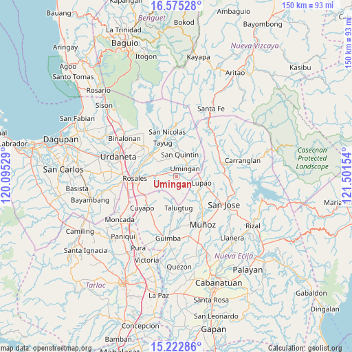
Umingan GPS coordinates[2]
15° 54' 0.756" North, 120° 47' 54.276" East
| Map corner | latitude | longitude |
|---|---|---|
| Upper-left | 16.57528°, | 120.09529° |
| Center: | 15.90021°, | 120.79841° |
| Lower-right: | 15.22286°, | 121.50154° |
| Map W x H: | 150.4×150.4 km | = 93.5×93.5mi |
| max Lat: | 20.78733° ⇑13.9% North |
| Umingan: | 15.90021° |
| min Lat: | ⇓86.1% South 4.65442° |
| min Long | Umingan | max Long |
| 117.04868° | 120.79841° | 126.58417° |
| W 17.7%⇐ | ⇒82.3% E |
Elevation
Elevation of Umingan is 96 m = 315 ft, and this is 8.1 m = 27 ft above average elevation for this country.
| Max E: |
2262 m = 7421 ft | 19.3% |
| Umingan | 96 m 315 ft | |
| Avg. | 87.9 m = 288 ft | |
Min E: |
-2 m = -7 ft | 80.7% |
See also: Philippines elevation on elevation.city.
Geographical zone
Umingan is located in North Torrid zone (between Equator and Tropic of Cancer). Distance of this Northern Tropic circle is 838 km =520.7 mi to North.| Distance of | km | miles | from Umingan |
|---|---|---|---|
| North Pole | 8239.1 | 5119.5 | to North |
| Arctic Circle | 5633.2 | 3500.3 | to North |
| Tropic Cancer | 838 | 520.7 | to North |
| Equator | 1767.9 | 1098.5 | to South |


Nearby cities:
15 places around Umingan: (largest is in red/bold)
• Alac
9.8 km =6.1 mi,  5°
5°
• Baloy
10.9 km =6.8 mi,  193°
193°
• Balungao
11.8 km =7.3 mi,  268°
268°
• Cabalaoangan
9.4 km =5.8 mi,  350°
350°
• Capandanan
12.9 km =8 mi,  300°
300°
• Diaz
7.1 km =4.4 mi,  147°
147°
• Esmeralda
9.6 km =6 mi,  247°
247°
• Lagasit
10.4 km =6.5 mi,  357°
357°
• Lupao
10.9 km =6.8 mi,  102°
102°
• Nancalobasaan
6.1 km =3.8 mi,  51°
51°
• Paitan Norte
9.7 km =6 mi,  219°
219°
• Panganiban
12.2 km =7.6 mi, 348°
• Sampaloc
11.8 km =7.3 mi,  141°
141°
• San Quintin
9.6 km =6 mi, 9°
• Talugtug
13.7 km =8.5 mi,  174°
174°
Sources, notices
• [Note1] Compared only with cities in Philippines existing in our database
• [Src1] Map data: © OpenStreetMap contributors (CC-BY-SA)
• [Src2] Other city data from geonames.org with taken over terms of usage.
• [Src3] Geographical zone / Annual Mean Temperature by Robert A. Rohde @ Wikipedia
