Cavite geodata
Cavite (Central Luzon) is a populated place; located in Philippines in Asia/Manila (GMT+8) time zone. With population of 2,402 people, there are 3457 cities with bigger population in this country. Compared to other cities in Philippines, 83.7% of cities are located further ↓South; 83.1% of cities are located further →East and 64.7% of cities have lower elevation than Cavite. Note1


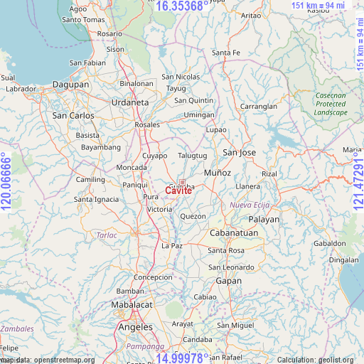
Cavite GPS coordinates[2]
15° 40' 40.26" North, 120° 46' 11.208" East
| Map corner | latitude | longitude |
|---|---|---|
| Upper-left | 16.35368°, | 120.06666° |
| Center: | 15.67785°, | 120.76978° |
| Lower-right: | 14.99978°, | 121.47291° |
| Map W x H: | 150.5×150.5 km | = 93.5×93.5mi |
| max Lat: | 20.78733° ⇑16.3% North |
| Cavite: | 15.67785° |
| min Lat: | ⇓83.7% South 4.65442° |
| min Long | Cavite | max Long |
| 117.04868° | 120.76978° | 126.58417° |
| W 16.9%⇐ | ⇒83.1% E |
Elevation
Elevation of Cavite is 41 m = 135 ft, and this is 46.9 m = 154 ft below average elevation for this country.
| Max E: |
2262 m = 7421 ft | 35.3% |
| Avg. | 87.9 m = 288 ft | |
| Cavite | 41 m = 135 ft | |
Min E: |
-2 m = -7 ft | 64.7% |
See also: Philippines elevation on elevation.city.
Geographical zone
Cavite is located in North Torrid zone (between Equator and Tropic of Cancer). Distance of this Northern Tropic circle is 862.7 km =536.1 mi to North.| Distance of | km | miles | from Cavite |
|---|---|---|---|
| North Pole | 8263.8 | 5134.9 | to North |
| Arctic Circle | 5658 | 3515.7 | to North |
| Tropic Cancer | 862.7 | 536.1 | to North |
| Equator | 1743.2 | 1083.2 | to South |


Nearby cities:
15 places around Cavite: (largest is in red/bold)
• Baloc
12.9 km =8 mi,  107°
107°
• Bunol
7 km =4.3 mi,  99°
99°
• Calibungan
10.1 km =6.3 mi,  208°
208°
• Cawayan Bugtong
5 km =3.1 mi,  171°
171°
• Guimba
1.9 km =1.2 mi,  184°
184°
• Lennec
3.9 km =2.4 mi,  279°
279°
• Maligaya
12.7 km =7.9 mi,  91°
91°
• Manacsac
9.5 km =5.9 mi, 166°
• Maturanoc
3.3 km =2.1 mi,  133°
133°
• Nagpandayan
8.5 km =5.3 mi, 180°
• Palusapis
10 km =6.2 mi, 86°
• San Andres
4.7 km =2.9 mi,  10°
10°
• Santa Rita
12.5 km =7.8 mi,  121°
121°
• Santo Rosario
10.5 km =6.5 mi, 110°
• Talugtug
12 km =7.5 mi,  21°
21°
Sources, notices
• [Note1] Compared only with cities in Philippines existing in our database
• [Src1] Map data: © OpenStreetMap contributors (CC-BY-SA)
• [Src2] Other city data from geonames.org with taken over terms of usage.
• [Src3] Geographical zone / Annual Mean Temperature by Robert A. Rohde @ Wikipedia
