Kaligutan geodata
Kaligutan (Davao) is a populated place; located in Philippines in Asia/Manila (GMT+8) time zone. With population of 2,789 people, there are 2805 cities with bigger population in this country. Compared to other cities in Philippines, 85.2% of cities are located further ↑North; 96.6% of cities are located further ←West and 81.2% of cities have lower elevation than Kaligutan. Note1


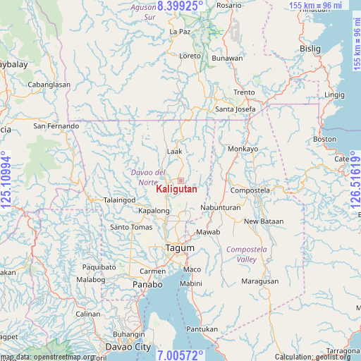
Kaligutan GPS coordinates[2]
7° 42' 11.016" North, 125° 48' 47.016" East
| Map corner | latitude | longitude |
|---|---|---|
| Upper-left | 8.39925°, | 125.10994° |
| Center: | 7.70306°, | 125.81306° |
| Lower-right: | 7.00572°, | 126.51619° |
| Map W x H: | 154.9×154.9 km | = 96.3×96.3mi |
| max Lat: | 20.78733° ⇑85.2% North |
| Kaligutan: | 7.70306° |
| min Lat: | ⇓14.8% South 4.65442° |
| min Long | Kaligutan | max Long |
| 117.04868° | 125.81306° | 126.58417° |
| W 96.6%⇐ | ⇒3.4% E |
Elevation
Elevation of Kaligutan is 101 m = 331 ft, and this is 13.1 m = 43 ft above average elevation for this country.
| Max E: |
2262 m = 7421 ft | 18.8% |
| Kaligutan | 101 m 331 ft | |
| Avg. | 87.9 m = 288 ft | |
Min E: |
-2 m = -7 ft | 81.2% |
See also: Philippines elevation on elevation.city.
Geographical zone
Kaligutan is located in North Torrid zone (between Equator and Tropic of Cancer). Distance of Equator is 856.5 km =532.2 mi to South.| Distance of | km | miles | from Kaligutan |
|---|---|---|---|
| North Pole | 9150.6 | 5685.9 | to North |
| Arctic Circle | 6544.7 | 4066.7 | to North |
| Tropic Cancer | 1749.4 | 1087 | to North |
| Equator | 856.5 | 532.2 | to South |


Nearby cities:
15 places around Kaligutan: (largest is in red/bold)
• Andop
18.7 km =11.6 mi,  339°
339°
• Cambanugoy
19.1 km =11.9 mi,  199°
199°
• Concepcion
12.3 km =7.6 mi,  295°
295°
• Del Pilar
15.6 km =9.7 mi,  174°
174°
• Gabuyan
19.1 km =11.9 mi,  236°
236°
• Limbaan
7.1 km =4.4 mi, 173°
• Linoan
19.7 km =12.2 mi,  115°
115°
• Magatos
19 km =11.8 mi,  210°
210°
• Montevista
19.4 km =12.1 mi,  93°
93°
• Nabunturan
19.9 km =12.4 mi, 122°
• New Bohol
20.2 km =12.6 mi, 172°
• New Corella
13 km =8.1 mi, 174°
• Pag-asa
20.1 km =12.5 mi,  225°
225°
• San Vicente
14.5 km =9 mi,  1°
1°
• Suz-on
19.8 km =12.3 mi,  256°
256°
Sources, notices
• [Note1] Compared only with cities in Philippines existing in our database
• [Src1] Map data: © OpenStreetMap contributors (CC-BY-SA)
• [Src2] Other city data from geonames.org with taken over terms of usage.
• [Src3] Geographical zone / Annual Mean Temperature by Robert A. Rohde @ Wikipedia
