Ogod geodata
Ogod (Bicol) is a populated place; located in Philippines in Asia/Manila (GMT+8) time zone. With population of 2,948 people, there are 2589 cities with bigger population in this country. Compared to other cities in Philippines, 56.8% of cities are located further ↓South; 64.2% of cities are located further ←West and 85.4% of cities have higher elevation than Ogod. Note1


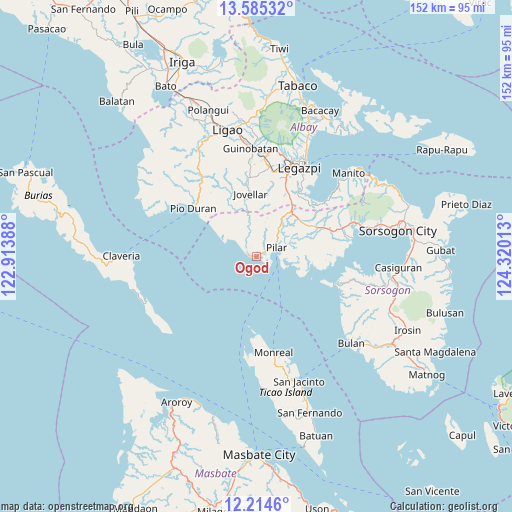
Ogod GPS coordinates[2]
12° 54' 3.24" North, 123° 37' 1.2" East
| Map corner | latitude | longitude |
|---|---|---|
| Upper-left | 13.58532°, | 122.91388° |
| Center: | 12.9009°, | 123.617° |
| Lower-right: | 12.2146°, | 124.32013° |
| Map W x H: | 152.4×152.4 km | = 94.7×94.7mi |
| max Lat: | 20.78733° ⇑43.2% North |
| Ogod: | 12.9009° |
| min Lat: | ⇓56.8% South 4.65442° |
| min Long | Ogod | max Long |
| 117.04868° | 123.617° | 126.58417° |
| W 64.2%⇐ | ⇒35.8% E |
Elevation
Elevation of Ogod is 8 m = 26 ft, and this is 79.9 m = 262 ft below average elevation for this country.
| Max E: |
2262 m = 7421 ft | 85.4% |
| Avg. | 87.9 m = 288 ft | |
| Ogod | 8 m = 26 ft | |
Min E: |
-2 m = -7 ft | 14.6% |
See also: Philippines elevation on elevation.city.
Geographical zone
Ogod is located in North Torrid zone (between Equator and Tropic of Cancer). Distance of this Northern Tropic circle is 1171.5 km =727.9 mi to North.| Distance of | km | miles | from Ogod |
|---|---|---|---|
| North Pole | 8572.6 | 5326.8 | to North |
| Arctic Circle | 5966.7 | 3707.5 | to North |
| Tropic Cancer | 1171.5 | 727.9 | to North |
| Equator | 1434.4 | 891.3 | to South |


Nearby cities:
15 places around Ogod: (largest is in red/bold)
• Aanislag
21.5 km =13.4 mi,  25°
25°
• Abucay
9.7 km =6 mi,  21°
21°
• Bangkirohan
22.2 km =13.8 mi,  39°
39°
• Cabiguan
12.4 km =7.7 mi,  87°
87°
• Cumadcad
20.7 km =12.9 mi,  64°
64°
• Dangcalan
4 km =2.5 mi,  296°
296°
• Donsol
2.4 km =1.5 mi,  282°
282°
• Jovellar
18.8 km =11.7 mi,  354°
354°
• Macalaya
16.8 km =10.4 mi, 94°
• Malidong
21.1 km =13.1 mi,  306°
306°
• Pilar
6.5 km =4 mi,  67°
67°
• Putiao
16.9 km =10.5 mi, 38°
• Salvacion
18.4 km =11.4 mi,  359°
359°
• San Rafael
7.2 km =4.5 mi,  99°
99°
• Villahermosa
19.2 km =11.9 mi, 32°
Sources, notices
• [Note1] Compared only with cities in Philippines existing in our database
• [Src1] Map data: © OpenStreetMap contributors (CC-BY-SA)
• [Src2] Other city data from geonames.org with taken over terms of usage.
• [Src3] Geographical zone / Annual Mean Temperature by Robert A. Rohde @ Wikipedia
