Rajal Norte geodata
Rajal Norte (Central Luzon) is a populated place; located in Philippines in Asia/Manila (GMT+8) time zone. With population of 10,281 people, there are 595 cities with bigger population in this country. Compared to other cities in Philippines, 81.2% of cities are located further ↓South; 80.6% of cities are located further →East and 54.4% of cities have lower elevation than Rajal Norte. Note1
Administrative division(s):
- Level 1: Central Luzon
- Level 2: Province of Nueva Ecija
- Level 3: Santa Rosa


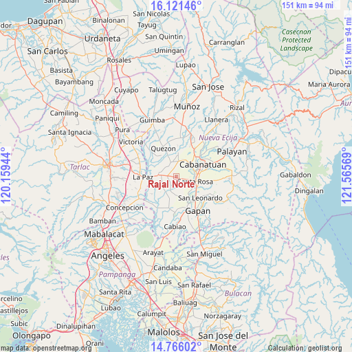
Rajal Norte GPS coordinates[2]
15° 26' 41.46" North, 120° 51' 45.216" East
| Map corner | latitude | longitude |
|---|---|---|
| Upper-left | 16.12146°, | 120.15944° |
| Center: | 15.44485°, | 120.86256° |
| Lower-right: | 14.76602°, | 121.56569° |
| Map W x H: | 150.7×150.7 km | = 93.6×93.6mi |
| max Lat: | 20.78733° ⇑18.8% North |
| Rajal Norte: | 15.44485° |
| min Lat: | ⇓81.2% South 4.65442° |
| min Long | Rajal Norte | max Long |
| 117.04868° | 120.86256° | 126.58417° |
| W 19.4%⇐ | ⇒80.6% E |
Elevation
Elevation of Rajal Norte is 27 m = 89 ft, and this is 60.9 m = 200 ft below average elevation for this country.
| Max E: |
2262 m = 7421 ft | 45.6% |
| Avg. | 87.9 m = 288 ft | |
| Rajal Norte | 27 m = 89 ft | |
Min E: |
-2 m = -7 ft | 54.4% |
See also: Philippines elevation on elevation.city.
Geographical zone
Rajal Norte is located in North Torrid zone (between Equator and Tropic of Cancer). Distance of this Northern Tropic circle is 888.6 km =552.2 mi to North.| Distance of | km | miles | from Rajal Norte |
|---|---|---|---|
| North Pole | 8289.8 | 5151 | to North |
| Arctic Circle | 5683.9 | 3531.8 | to North |
| Tropic Cancer | 888.6 | 552.2 | to North |
| Equator | 1717.3 | 1067.1 | to South |


Nearby cities:
15 places around Rajal Norte: (largest is in red/bold)
• Aliaga
6.5 km =4 mi,  341°
341°
• Batitang
8.1 km =5 mi,  232°
232°
• Bibiclat
8.6 km =5.3 mi,  359°
359°
• Carmen
3.8 km =2.4 mi,  273°
273°
• Concepcion
6.6 km =4.1 mi, 269°
• Lambakin
8.1 km =5 mi,  181°
181°
• Macarse
9.7 km =6 mi,  256°
256°
• Marawa
4 km =2.5 mi,  220°
220°
• Putlod
8.3 km =5.2 mi, 176°
• San Felipe Old
7.9 km =4.9 mi,  37°
37°
• San Francisco
10.2 km =6.3 mi,  193°
193°
• Santa Barbara
9.8 km =6.1 mi, 226°
• Santa Rosa
8.4 km =5.2 mi,  106°
106°
• Santo Rosario
3.1 km =1.9 mi, 111°
• Tabuating
10.2 km =6.3 mi,  124°
124°
Sources, notices
• [Note1] Compared only with cities in Philippines existing in our database
• [Src1] Map data: © OpenStreetMap contributors (CC-BY-SA)
• [Src2] Other city data from geonames.org with taken over terms of usage.
• [Src3] Geographical zone / Annual Mean Temperature by Robert A. Rohde @ Wikipedia
