Cardona geodata
Cardona (Central Luzon) is a populated place; located in Philippines in Asia/Manila (GMT+8) time zone. With population of 2,594 people, there are 3117 cities with bigger population in this country. Compared to other cities in Philippines, 82.4% of cities are located further ↓South; 88.5% of cities are located further →East and 62.2% of cities have lower elevation than Cardona. Note1


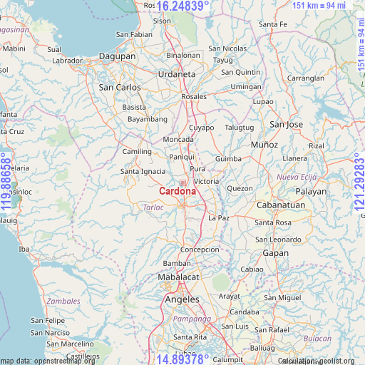
Cardona GPS coordinates[2]
15° 34' 19.92" North, 120° 35' 22.92" East
| Map corner | latitude | longitude |
|---|---|---|
| Upper-left | 16.24839°, | 119.88658° |
| Center: | 15.5722°, | 120.5897° |
| Lower-right: | 14.89378°, | 121.29283° |
| Map W x H: | 150.6×150.6 km | = 93.6×93.6mi |
| max Lat: | 20.78733° ⇑17.6% North |
| Cardona: | 15.5722° |
| min Lat: | ⇓82.4% South 4.65442° |
| min Long | Cardona | max Long |
| 117.04868° | 120.5897° | 126.58417° |
| W 11.5%⇐ | ⇒88.5% E |
Elevation
Elevation of Cardona is 37 m = 121 ft, and this is 50.9 m = 167 ft below average elevation for this country.
| Max E: |
2262 m = 7421 ft | 37.8% |
| Avg. | 87.9 m = 288 ft | |
| Cardona | 37 m = 121 ft | |
Min E: |
-2 m = -7 ft | 62.2% |
See also: Philippines elevation on elevation.city.
Geographical zone
Cardona is located in North Torrid zone (between Equator and Tropic of Cancer). Distance of this Northern Tropic circle is 874.5 km =543.4 mi to North.| Distance of | km | miles | from Cardona |
|---|---|---|---|
| North Pole | 8275.6 | 5142.2 | to North |
| Arctic Circle | 5669.7 | 3523 | to North |
| Tropic Cancer | 874.5 | 543.4 | to North |
| Equator | 1731.5 | 1075.9 | to South |


Nearby cities:
15 places around Cardona: (largest is in red/bold)
• Amacalan
2.5 km =1.6 mi,  65°
65°
• Bakulong
6.5 km =4 mi,  126°
126°
• Buenlag
6.2 km =3.9 mi,  352°
352°
• Bularit
3.5 km =2.2 mi,  97°
97°
• Calayaan
8.1 km =5 mi,  266°
266°
• Estipona
5.5 km =3.4 mi, 68°
• Gerona
3.9 km =2.4 mi,  12°
12°
• Maluid
7.2 km =4.5 mi,  110°
110°
• Padapada
8.2 km =5.1 mi,  253°
253°
• Pura
8.6 km =5.3 mi,  46°
46°
• San Jacinto
9.1 km =5.7 mi, 109°
• San Juan de Mata
7.6 km =4.7 mi,  237°
237°
• San Nicolas
9.4 km =5.8 mi,  81°
81°
• Sinait
4 km =2.5 mi,  187°
187°
• Tariji
6.3 km =3.9 mi,  155°
155°
Sources, notices
• [Note1] Compared only with cities in Philippines existing in our database
• [Src1] Map data: © OpenStreetMap contributors (CC-BY-SA)
• [Src2] Other city data from geonames.org with taken over terms of usage.
• [Src3] Geographical zone / Annual Mean Temperature by Robert A. Rohde @ Wikipedia
