Malinao geodata
Malinao (Bicol) is a seat of a third-order administrative division; located in Philippines in Asia/Manila (GMT+8) time zone. In our database, there are 4166 cities with bigger population. Compared to other cities in Philippines, 61.1% of cities are located further ↓South; 65.7% of cities are located further ←West and 92.7% of cities have higher elevation than Malinao. Note1


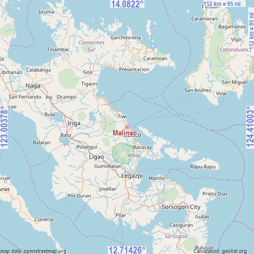
Malinao GPS coordinates[2]
13° 23' 57.12" North, 123° 42' 24.84" East
| Map corner | latitude | longitude |
|---|---|---|
| Upper-left | 14.0822°, | 123.00378° |
| Center: | 13.3992°, | 123.7069° |
| Lower-right: | 12.71426°, | 124.41003° |
| Map W x H: | 152.1×152.1 km | = 94.5×94.5mi |
| max Lat: | 20.78733° ⇑38.9% North |
| Malinao: | 13.3992° |
| min Lat: | ⇓61.1% South 4.65442° |
| min Long | Malinao | max Long |
| 117.04868° | 123.7069° | 126.58417° |
| W 65.7%⇐ | ⇒34.3% E |
Elevation
Elevation of Malinao is 6 m = 20 ft, and this is 81.9 m = 269 ft below average elevation for this country.
| Max E: |
2262 m = 7421 ft | 92.7% |
| Avg. | 87.9 m = 288 ft | |
| Malinao | 6 m = 20 ft | |
Min E: |
-2 m = -7 ft | 7.3% |
See also: Philippines elevation on elevation.city.
Geographical zone
Malinao is located in North Torrid zone (between Equator and Tropic of Cancer). Distance of this Northern Tropic circle is 1116.1 km =693.5 mi to North.| Distance of | km | miles | from Malinao |
|---|---|---|---|
| North Pole | 8517.2 | 5292.3 | to North |
| Arctic Circle | 5911.3 | 3673.1 | to North |
| Tropic Cancer | 1116.1 | 693.5 | to North |
| Equator | 1489.9 | 925.8 | to South |


Nearby cities:
15 places around Malinao: (largest is in red/bold)
• Bagumbayan
7.1 km =4.4 mi,  322°
322°
• Balading
1.1 km =0.7 mi,  149°
149°
• Banag
2.3 km =1.4 mi,  189°
189°
• Baybay
1.2 km =0.7 mi,  35°
35°
• Buang
12 km =7.5 mi,  215°
215°
• Estancia
5.4 km =3.4 mi,  213°
213°
• Labnig
3.9 km =2.4 mi,  230°
230°
• Malilipot
9.6 km =6 mi,  159°
159°
• Miliroc
6.1 km =3.8 mi, 185°
• Naagas
5.1 km =3.2 mi, 322°
• San Francisco
10.3 km =6.4 mi, 153°
• Sugcad
3.7 km =2.3 mi, 191°
• Tabaco
5.4 km =3.4 mi, 147°
• Tagoytoy
3.6 km =2.2 mi,  300°
300°
• Tiwi
7.2 km =4.5 mi,  336°
336°
Sources, notices
• [Note1] Compared only with cities in Philippines existing in our database
• [Src1] Map data: © OpenStreetMap contributors (CC-BY-SA)
• [Src2] Other city data from geonames.org with taken over terms of usage.
• [Src3] Geographical zone / Annual Mean Temperature by Robert A. Rohde @ Wikipedia
