Labnig geodata
Labnig (Bicol) is a populated place; located in Philippines in Asia/Manila (GMT+8) time zone. With population of 2,983 people, there are 2547 cities with bigger population in this country. Compared to other cities in Philippines, 60.9% of cities are located further ↓South; 65.2% of cities are located further ←West and 56.1% of cities have higher elevation than Labnig. Note1


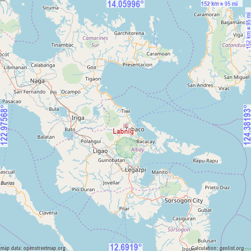
Labnig GPS coordinates[2]
13° 22' 36.84" North, 123° 40' 43.68" East
| Map corner | latitude | longitude |
|---|---|---|
| Upper-left | 14.05996°, | 122.97568° |
| Center: | 13.3769°, | 123.6788° |
| Lower-right: | 12.6919°, | 124.38193° |
| Map W x H: | 152.1×152.1 km | = 94.5×94.5mi |
| max Lat: | 20.78733° ⇑39.1% North |
| Labnig: | 13.3769° |
| min Lat: | ⇓60.9% South 4.65442° |
| min Long | Labnig | max Long |
| 117.04868° | 123.6788° | 126.58417° |
| W 65.2%⇐ | ⇒34.8% E |
Elevation
Elevation of Labnig is 19 m = 62 ft, and this is 68.9 m = 226 ft below average elevation for this country.
| Max E: |
2262 m = 7421 ft | 56.1% |
| Avg. | 87.9 m = 288 ft | |
| Labnig | 19 m = 62 ft | |
Min E: |
-2 m = -7 ft | 43.9% |
See also: Philippines elevation on elevation.city.
Geographical zone
Labnig is located in North Torrid zone (between Equator and Tropic of Cancer). Distance of this Northern Tropic circle is 1118.5 km =695 mi to North.| Distance of | km | miles | from Labnig |
|---|---|---|---|
| North Pole | 8519.7 | 5293.9 | to North |
| Arctic Circle | 5913.8 | 3674.7 | to North |
| Tropic Cancer | 1118.5 | 695 | to North |
| Equator | 1487.4 | 924.2 | to South |


Nearby cities:
15 places around Labnig: (largest is in red/bold)
• Bagumbayan
8.2 km =5.1 mi,  350°
350°
• Balading
3.9 km =2.4 mi,  67°
67°
• Banag
2.7 km =1.7 mi,  85°
85°
• Baybay
5.1 km =3.2 mi,  47°
47°
• Buang
8.3 km =5.2 mi,  208°
208°
• Estancia
2 km =1.2 mi,  177°
177°
• Malilipot
9.1 km =5.7 mi,  135°
135°
• Malinao
3.9 km =2.4 mi, 50°
• Miliroc
4.4 km =2.7 mi, 144°
• Naagas
6.5 km =4 mi,  359°
359°
• San Francisco
10.2 km =6.3 mi,  131°
131°
• Sugcad
2.6 km =1.6 mi,  116°
116°
• Tabaco
6.3 km =3.9 mi,  108°
108°
• Tagoytoy
4.3 km =2.7 mi, 358°
• Tiwi
9.1 km =5.7 mi,  1°
1°
Sources, notices
• [Note1] Compared only with cities in Philippines existing in our database
• [Src1] Map data: © OpenStreetMap contributors (CC-BY-SA)
• [Src2] Other city data from geonames.org with taken over terms of usage.
• [Src3] Geographical zone / Annual Mean Temperature by Robert A. Rohde @ Wikipedia
