Sampaloc geodata
Sampaloc (Calabarzon) is a populated place; located in Philippines in Asia/Manila (GMT+8) time zone. With population of 6,743 people, there are 929 cities with bigger population in this country. Compared to other cities in Philippines, 71.3% of cities are located further ↓South; 64.8% of cities are located further →East and 74.9% of cities have lower elevation than Sampaloc. Note1


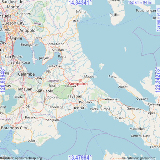
Sampaloc GPS coordinates[2]
14° 9' 45.72" North, 121° 38' 22.56" East
| Map corner | latitude | longitude |
|---|---|---|
| Upper-left | 14.84341°, | 120.93648° |
| Center: | 14.1627°, | 121.6396° |
| Lower-right: | 13.47994°, | 122.34273° |
| Map W x H: | 151.6×151.6 km | = 94.2×94.2mi |
| max Lat: | 20.78733° ⇑28.7% North |
| Sampaloc: | 14.1627° |
| min Lat: | ⇓71.3% South 4.65442° |
| min Long | Sampaloc | max Long |
| 117.04868° | 121.6396° | 126.58417° |
| W 35.2%⇐ | ⇒64.8% E |
Elevation
Elevation of Sampaloc is 68 m = 223 ft, and this is 19.9 m = 65 ft below average elevation for this country.
| Max E: |
2262 m = 7421 ft | 25.1% |
| Avg. | 87.9 m = 288 ft | |
| Sampaloc | 68 m = 223 ft | |
Min E: |
-2 m = -7 ft | 74.9% |
See also: Philippines elevation on elevation.city.
Geographical zone
Sampaloc is located in North Torrid zone (between Equator and Tropic of Cancer). Distance of this Northern Tropic circle is 1031.2 km =640.8 mi to North.| Distance of | km | miles | from Sampaloc |
|---|---|---|---|
| North Pole | 8432.3 | 5239.6 | to North |
| Arctic Circle | 5826.4 | 3620.4 | to North |
| Tropic Cancer | 1031.2 | 640.8 | to North |
| Equator | 1574.7 | 978.5 | to South |


Nearby cities:
15 places around Sampaloc: (largest is in red/bold)
• Binahaan
22.7 km =14.1 mi,  147°
147°
• Cagsiay
13.3 km =8.3 mi,  63°
63°
• Calumpang
21.6 km =13.4 mi,  206°
206°
• Cavinti
16.9 km =10.5 mi,  302°
302°
• Kalayaan
22.3 km =13.9 mi,  339°
339°
• Lilio
22.2 km =13.8 mi,  260°
260°
• Lucban
10.6 km =6.6 mi,  238°
238°
• Luisiana
14.1 km =8.8 mi,  280°
280°
• Majayjay
18.1 km =11.2 mi, 264°
• Mamala
21 km =13 mi,  219°
219°
• Mauban
10.3 km =6.4 mi,  72°
72°
• San Antonio
15.6 km =9.7 mi,  285°
285°
• San Diego
16.7 km =10.4 mi, 279°
• Santo Tomas
15.2 km =9.4 mi, 278°
• Tayabas
16 km =9.9 mi,  198°
198°
Sources, notices
• [Note1] Compared only with cities in Philippines existing in our database
• [Src1] Map data: © OpenStreetMap contributors (CC-BY-SA)
• [Src2] Other city data from geonames.org with taken over terms of usage.
• [Src3] Geographical zone / Annual Mean Temperature by Robert A. Rohde @ Wikipedia
