Lennec geodata
Lennec (Central Luzon) is a populated place; located in Philippines in Asia/Manila (GMT+8) time zone. With population of 3,142 people, there are 2368 cities with bigger population in this country. Compared to other cities in Philippines, 83.8% of cities are located further ↓South; 84% of cities are located further →East and 62.2% of cities have lower elevation than Lennec. Note1


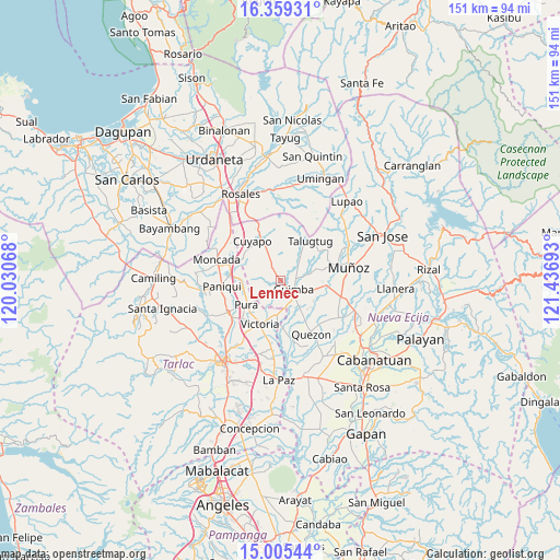
Lennec GPS coordinates[2]
15° 41' 0.6" North, 120° 44' 1.68" East
| Map corner | latitude | longitude |
|---|---|---|
| Upper-left | 16.35931°, | 120.03068° |
| Center: | 15.6835°, | 120.7338° |
| Lower-right: | 15.00544°, | 121.43693° |
| Map W x H: | 150.5×150.5 km | = 93.5×93.5mi |
| max Lat: | 20.78733° ⇑16.2% North |
| Lennec: | 15.6835° |
| min Lat: | ⇓83.8% South 4.65442° |
| min Long | Lennec | max Long |
| 117.04868° | 120.7338° | 126.58417° |
| W 16%⇐ | ⇒84% E |
Elevation
Elevation of Lennec is 37 m = 121 ft, and this is 50.9 m = 167 ft below average elevation for this country.
| Max E: |
2262 m = 7421 ft | 37.8% |
| Avg. | 87.9 m = 288 ft | |
| Lennec | 37 m = 121 ft | |
Min E: |
-2 m = -7 ft | 62.2% |
See also: Philippines elevation on elevation.city.
Geographical zone
Lennec is located in North Torrid zone (between Equator and Tropic of Cancer). Distance of this Northern Tropic circle is 862.1 km =535.7 mi to North.| Distance of | km | miles | from Lennec |
|---|---|---|---|
| North Pole | 8263.2 | 5134.5 | to North |
| Arctic Circle | 5657.3 | 3515.3 | to North |
| Tropic Cancer | 862.1 | 535.7 | to North |
| Equator | 1743.8 | 1083.5 | to South |


Nearby cities:
15 places around Lennec: (largest is in red/bold)
• Anao
12.7 km =7.9 mi,  293°
293°
• Balite
10.7 km =6.6 mi,  246°
246°
• Bunol
10.9 km =6.8 mi,  99°
99°
• Calibungan
9.5 km =5.9 mi,  186°
186°
• Cavite
3.9 km =2.4 mi, 99°
• Cawayan Bugtong
7.2 km =4.5 mi,  140°
140°
• Guimba
4.5 km =2.8 mi,  124°
124°
• Manacsac
11.6 km =7.2 mi,  147°
147°
• Maturanoc
6.9 km =4.3 mi, 115°
• Nagpandayan
9.9 km =6.2 mi,  157°
157°
• Pance
12.2 km =7.6 mi,  272°
272°
• Pura
11.3 km =7 mi,  234°
234°
• Ramos
10.2 km =6.3 mi,  258°
258°
• San Andres
6.1 km =3.8 mi,  49°
49°
• San Nicolas
12.6 km =7.8 mi,  209°
209°
Sources, notices
• [Note1] Compared only with cities in Philippines existing in our database
• [Src1] Map data: © OpenStreetMap contributors (CC-BY-SA)
• [Src2] Other city data from geonames.org with taken over terms of usage.
• [Src3] Geographical zone / Annual Mean Temperature by Robert A. Rohde @ Wikipedia
