Anao geodata
Anao (Central Luzon) is a seat of a third-order administrative division; located in Philippines in Asia/Manila (GMT+8) time zone. In our database, there are 4166 cities with bigger population. Compared to other cities in Philippines, 84.2% of cities are located further ↓South; 87.3% of cities are located further →East and 50.3% of cities have higher elevation than Anao. Note1


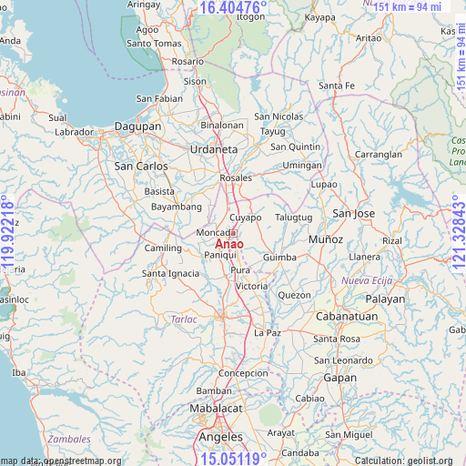
Anao GPS coordinates[2]
15° 43' 44.76" North, 120° 37' 31.08" East
| Map corner | latitude | longitude |
|---|---|---|
| Upper-left | 16.40476°, | 119.92218° |
| Center: | 15.7291°, | 120.6253° |
| Lower-right: | 15.05119°, | 121.32843° |
| Map W x H: | 150.5×150.5 km | = 93.5×93.5mi |
| max Lat: | 20.78733° ⇑15.8% North |
| Anao: | 15.7291° |
| min Lat: | ⇓84.2% South 4.65442° |
| min Long | Anao | max Long |
| 117.04868° | 120.6253° | 126.58417° |
| W 12.7%⇐ | ⇒87.3% E |
Elevation
Elevation of Anao is 23 m = 75 ft, and this is 64.9 m = 213 ft below average elevation for this country.
| Max E: |
2262 m = 7421 ft | 50.3% |
| Avg. | 87.9 m = 288 ft | |
| Anao | 23 m = 75 ft | |
Min E: |
-2 m = -7 ft | 49.7% |
See also: Philippines elevation on elevation.city.
Geographical zone
Anao is located in North Torrid zone (between Equator and Tropic of Cancer). Distance of this Northern Tropic circle is 857 km =532.5 mi to North.| Distance of | km | miles | from Anao |
|---|---|---|---|
| North Pole | 8258.1 | 5131.3 | to North |
| Arctic Circle | 5652.3 | 3512.2 | to North |
| Tropic Cancer | 857 | 532.5 | to North |
| Equator | 1748.9 | 1086.7 | to South |


Nearby cities:
15 places around Anao: (largest is in red/bold)
• Balite
9.6 km =6 mi,  169°
169°
• Baquero Norte
7.7 km =4.8 mi,  259°
259°
• Burgos
5.7 km =3.5 mi,  269°
269°
• Cabayaoasan
10.8 km =6.7 mi,  227°
227°
• Calancuasan Norte
8.2 km =5.1 mi,  11°
11°
• Cuyapo
7.2 km =4.5 mi,  35°
35°
• Estacion
3.8 km =2.4 mi,  208°
208°
• Lanat
7.3 km =4.5 mi,  342°
342°
• Moncada
5.5 km =3.4 mi,  277°
277°
• Nampicuan
0.3 km =0.2 mi,  352°
352°
• Nancamarinan
11.2 km =7 mi,  237°
237°
• Pance
4.5 km =2.8 mi,  187°
187°
• Paniqui
8.2 km =5.1 mi,  215°
215°
• Ramos
7.3 km =4.5 mi, 167°
• San Manuel
8 km =5 mi, 347°
Sources, notices
• [Note1] Compared only with cities in Philippines existing in our database
• [Src1] Map data: © OpenStreetMap contributors (CC-BY-SA)
• [Src2] Other city data from geonames.org with taken over terms of usage.
• [Src3] Geographical zone / Annual Mean Temperature by Robert A. Rohde @ Wikipedia
