San Andres geodata
San Andres (Central Luzon) is a populated place; located in Philippines in Asia/Manila (GMT+8) time zone. With population of 3,329 people, there are 2198 cities with bigger population in this country. Compared to other cities in Philippines, 84.1% of cities are located further ↓South; 82.8% of cities are located further →East and 70.5% of cities have lower elevation than San Andres. Note1


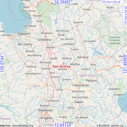
San Andres GPS coordinates[2]
15° 43' 9.408" North, 120° 46' 39.072" East
| Map corner | latitude | longitude |
|---|---|---|
| Upper-left | 16.39497°, | 120.0744° |
| Center: | 15.71928°, | 120.77752° |
| Lower-right: | 15.04134°, | 121.48065° |
| Map W x H: | 150.5×150.5 km | = 93.5×93.5mi |
| max Lat: | 20.78733° ⇑15.9% North |
| San Andres: | 15.71928° |
| min Lat: | ⇓84.1% South 4.65442° |
| min Long | San Andres | max Long |
| 117.04868° | 120.77752° | 126.58417° |
| W 17.2%⇐ | ⇒82.8% E |
Elevation
Elevation of San Andres is 53 m = 174 ft, and this is 34.9 m = 115 ft below average elevation for this country.
| Max E: |
2262 m = 7421 ft | 29.5% |
| Avg. | 87.9 m = 288 ft | |
| San Andres | 53 m = 174 ft | |
Min E: |
-2 m = -7 ft | 70.5% |
See also: Philippines elevation on elevation.city.
Geographical zone
San Andres is located in North Torrid zone (between Equator and Tropic of Cancer). Distance of this Northern Tropic circle is 858.1 km =533.2 mi to North.| Distance of | km | miles | from San Andres |
|---|---|---|---|
| North Pole | 8259.2 | 5132 | to North |
| Arctic Circle | 5653.4 | 3512.9 | to North |
| Tropic Cancer | 858.1 | 533.2 | to North |
| Equator | 1747.8 | 1086 | to South |


Nearby cities:
15 places around San Andres: (largest is in red/bold)
• Baloy
9.6 km =6 mi,  357°
357°
• Bunol
8.4 km =5.2 mi,  133°
133°
• Cavite
4.7 km =2.9 mi,  190°
190°
• Cawayan Bugtong
9.5 km =5.9 mi,  180°
180°
• Guimba
6.6 km =4.1 mi, 188°
• Lennec
6.1 km =3.8 mi,  229°
229°
• Maligaya
12.9 km =8 mi,  112°
112°
• Maturanoc
7.1 km =4.4 mi,  167°
167°
• Muñoz
13.4 km =8.3 mi,  91°
91°
• Nagpandayan
13.1 km =8.1 mi, 184°
• Paitan Norte
13.3 km =8.3 mi,  342°
342°
• Palusapis
10 km =6.2 mi, 113°
• Santo Rosario
12.2 km =7.6 mi, 132°
• Talugtug
7.4 km =4.6 mi,  28°
28°
• Villa Isla
11.1 km =6.9 mi,  59°
59°
Sources, notices
• [Note1] Compared only with cities in Philippines existing in our database
• [Src1] Map data: © OpenStreetMap contributors (CC-BY-SA)
• [Src2] Other city data from geonames.org with taken over terms of usage.
• [Src3] Geographical zone / Annual Mean Temperature by Robert A. Rohde @ Wikipedia
