Balite geodata
Balite (Central Luzon) is a populated place; located in Philippines in Asia/Manila (GMT+8) time zone. With population of 4,360 people, there are 1554 cities with bigger population in this country. Compared to other cities in Philippines, 83.3% of cities are located further ↓South; 86.7% of cities are located further →East and 53.5% of cities have lower elevation than Balite. Note1


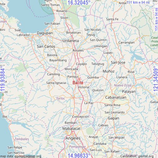
Balite GPS coordinates[2]
15° 38' 40.236" North, 120° 38' 31.056" East
| Map corner | latitude | longitude |
|---|---|---|
| Upper-left | 16.32045°, | 119.93884° |
| Center: | 15.64451°, | 120.64196° |
| Lower-right: | 14.96633°, | 121.34509° |
| Map W x H: | 150.6×150.6 km | = 93.6×93.6mi |
| max Lat: | 20.78733° ⇑16.7% North |
| Balite: | 15.64451° |
| min Lat: | ⇓83.3% South 4.65442° |
| min Long | Balite | max Long |
| 117.04868° | 120.64196° | 126.58417° |
| W 13.3%⇐ | ⇒86.7% E |
Elevation
Elevation of Balite is 26 m = 85 ft, and this is 61.9 m = 203 ft below average elevation for this country.
| Max E: |
2262 m = 7421 ft | 46.5% |
| Avg. | 87.9 m = 288 ft | |
| Balite | 26 m = 85 ft | |
Min E: |
-2 m = -7 ft | 53.5% |
See also: Philippines elevation on elevation.city.
Geographical zone
Balite is located in North Torrid zone (between Equator and Tropic of Cancer). Distance of this Northern Tropic circle is 866.4 km =538.4 mi to North.| Distance of | km | miles | from Balite |
|---|---|---|---|
| North Pole | 8267.6 | 5137.2 | to North |
| Arctic Circle | 5661.7 | 3518 | to North |
| Tropic Cancer | 866.4 | 538.4 | to North |
| Equator | 1739.5 | 1080.9 | to South |


Nearby cities:
15 places around Balite: (largest is in red/bold)
• Amacalan
7.7 km =4.8 mi,  205°
205°
• Anao
9.6 km =6 mi,  349°
349°
• Buenlag
6.7 km =4.2 mi,  253°
253°
• Bularit
8.8 km =5.5 mi,  194°
194°
• Cardona
9.8 km =6.1 mi, 214°
• Estacion
7.1 km =4.4 mi,  329°
329°
• Estipona
6.1 km =3.8 mi,  184°
184°
• Gerona
6.3 km =3.9 mi,  228°
228°
• Nampicuan
9.8 km =6.1 mi, 349°
• Pance
5.4 km =3.4 mi, 334°
• Paniqui
7.1 km =4.4 mi,  292°
292°
• Pura
2.3 km =1.4 mi,  163°
163°
• Ramos
2.3 km =1.4 mi,  356°
356°
• San Nicolas
7.7 km =4.8 mi,  151°
151°
• Victoria
8.6 km =5.3 mi, 149°
Sources, notices
• [Note1] Compared only with cities in Philippines existing in our database
• [Src1] Map data: © OpenStreetMap contributors (CC-BY-SA)
• [Src2] Other city data from geonames.org with taken over terms of usage.
• [Src3] Geographical zone / Annual Mean Temperature by Robert A. Rohde @ Wikipedia
