Ramos geodata
Ramos (Central Luzon) is a seat of a third-order administrative division; located in Philippines in Asia/Manila (GMT+8) time zone. With population of 15,066 people, there are 447 cities with bigger population in this country. Compared to other cities in Philippines, 83.5% of cities are located further ↓South; 86.8% of cities are located further →East and 53.5% of cities have lower elevation than Ramos. Note1


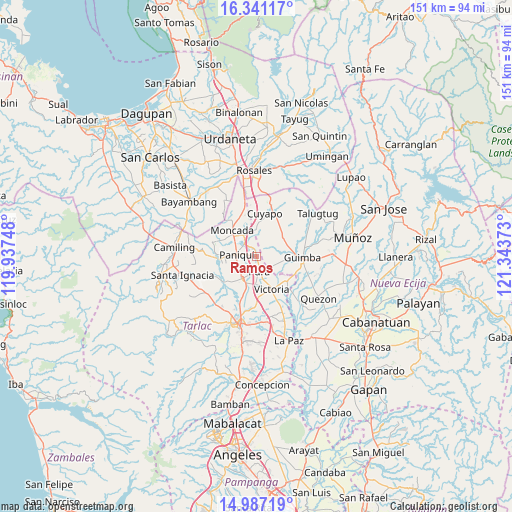
Ramos GPS coordinates[2]
15° 39' 55.08" North, 120° 38' 26.16" East
| Map corner | latitude | longitude |
|---|---|---|
| Upper-left | 16.34117°, | 119.93748° |
| Center: | 15.6653°, | 120.6406° |
| Lower-right: | 14.98719°, | 121.34373° |
| Map W x H: | 150.5×150.6 km | = 93.5×93.6mi |
| max Lat: | 20.78733° ⇑16.5% North |
| Ramos: | 15.6653° |
| min Lat: | ⇓83.5% South 4.65442° |
| min Long | Ramos | max Long |
| 117.04868° | 120.6406° | 126.58417° |
| W 13.2%⇐ | ⇒86.8% E |
Elevation
Elevation of Ramos is 26 m = 85 ft, and this is 61.9 m = 203 ft below average elevation for this country.
| Max E: |
2262 m = 7421 ft | 46.5% |
| Avg. | 87.9 m = 288 ft | |
| Ramos | 26 m = 85 ft | |
Min E: |
-2 m = -7 ft | 53.5% |
See also: Philippines elevation on elevation.city.
Geographical zone
Ramos is located in North Torrid zone (between Equator and Tropic of Cancer). Distance of this Northern Tropic circle is 864.1 km =536.9 mi to North.| Distance of | km | miles | from Ramos |
|---|---|---|---|
| North Pole | 8265.2 | 5135.8 | to North |
| Arctic Circle | 5659.4 | 3516.6 | to North |
| Tropic Cancer | 864.1 | 536.9 | to North |
| Equator | 1741.8 | 1082.3 | to South |


Nearby cities:
15 places around Ramos: (largest is in red/bold)
• Amacalan
9.8 km =6.1 mi,  198°
198°
• Anao
7.3 km =4.5 mi,  347°
347°
• Balite
2.3 km =1.4 mi,  176°
176°
• Buenlag
7.6 km =4.7 mi,  236°
236°
• Burgos
10.2 km =6.3 mi,  314°
314°
• Cabayaoasan
9.6 km =6 mi,  268°
268°
• Estacion
5.1 km =3.2 mi,  317°
317°
• Estipona
8.4 km =5.2 mi, 182°
• Gerona
8 km =5 mi,  215°
215°
• Lennec
10.2 km =6.3 mi,  78°
78°
• Nampicuan
7.5 km =4.7 mi, 347°
• Pance
3.4 km =2.1 mi, 319°
• Paniqui
6.4 km =4 mi, 273°
• Pura
4.6 km =2.9 mi,  170°
170°
• San Nicolas
9.8 km =6.1 mi,  156°
156°
Sources, notices
• [Note1] Compared only with cities in Philippines existing in our database
• [Src1] Map data: © OpenStreetMap contributors (CC-BY-SA)
• [Src2] Other city data from geonames.org with taken over terms of usage.
• [Src3] Geographical zone / Annual Mean Temperature by Robert A. Rohde @ Wikipedia
