Gibato geodata
Gibato (Western Visayas) is a populated place; located in Philippines in Asia/Manila (GMT+8) time zone. With population of 2,360 people, there are 3538 cities with bigger population in this country. Compared to other cities in Philippines, 54.2% of cities are located further ↑North; 50% of cities are located further ←West and 73.1% of cities have lower elevation than Gibato. Note1


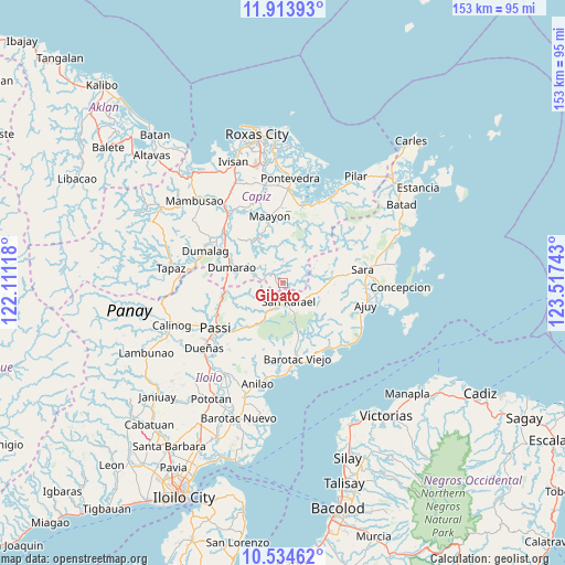
Gibato GPS coordinates[2]
11° 13' 30.36" North, 122° 48' 51.48" East
| Map corner | latitude | longitude |
|---|---|---|
| Upper-left | 11.91393°, | 122.11118° |
| Center: | 11.2251°, | 122.8143° |
| Lower-right: | 10.53462°, | 123.51743° |
| Map W x H: | 153.4×153.4 km | = 95.3×95.3mi |
| max Lat: | 20.78733° ⇑54.2% North |
| Gibato: | 11.2251° |
| min Lat: | ⇓45.8% South 4.65442° |
| min Long | Gibato | max Long |
| 117.04868° | 122.8143° | 126.58417° |
| W 50%⇐ | ⇒50% E |
Elevation
Elevation of Gibato is 61 m = 200 ft, and this is 26.9 m = 88 ft below average elevation for this country.
| Max E: |
2262 m = 7421 ft | 26.9% |
| Avg. | 87.9 m = 288 ft | |
| Gibato | 61 m = 200 ft | |
Min E: |
-2 m = -7 ft | 73.1% |
See also: Philippines elevation on elevation.city.
Geographical zone
Gibato is located in North Torrid zone (between Equator and Tropic of Cancer). Distance of Equator is 1248.1 km =775.5 mi to South.| Distance of | km | miles | from Gibato |
|---|---|---|---|
| North Pole | 8758.9 | 5442.5 | to North |
| Arctic Circle | 6153.1 | 3823.4 | to North |
| Tropic Cancer | 1357.8 | 843.7 | to North |
| Equator | 1248.1 | 775.5 | to South |


Nearby cities:
15 places around Gibato: (largest is in red/bold)
• Abaca
14.8 km =9.2 mi,  226°
226°
• Aglalana
17.8 km =11.1 mi,  253°
253°
• Alimono
11.9 km =7.4 mi, 248°
• Asturga
3.5 km =2.2 mi,  337°
337°
• Barotac Viejo
20.8 km =12.9 mi,  168°
168°
• Bungsuan
12.8 km =8 mi,  277°
277°
• Cuartero
20.4 km =12.7 mi,  309°
309°
• De la Paz
18.3 km =11.4 mi,  192°
192°
• Dumarao
14.4 km =8.9 mi,  288°
288°
• Jaguimitan
13.7 km =8.5 mi, 226°
• Lantangan
19.6 km =12.2 mi,  24°
24°
• Lemery
12.3 km =7.6 mi,  89°
89°
• Maayon
18.2 km =11.3 mi,  350°
350°
• Mapili
15.4 km =9.6 mi,  212°
212°
• San Rafael
5.4 km =3.4 mi,  164°
164°
Sources, notices
• [Note1] Compared only with cities in Philippines existing in our database
• [Src1] Map data: © OpenStreetMap contributors (CC-BY-SA)
• [Src2] Other city data from geonames.org with taken over terms of usage.
• [Src3] Geographical zone / Annual Mean Temperature by Robert A. Rohde @ Wikipedia
