Asturga geodata
Asturga (Western Visayas) is a populated place; located in Philippines in Asia/Manila (GMT+8) time zone. With population of 2,702 people, there are 2943 cities with bigger population in this country. Compared to other cities in Philippines, 53.8% of cities are located further ↑North; 50.2% of cities are located further →East and 75.8% of cities have lower elevation than Asturga. Note1


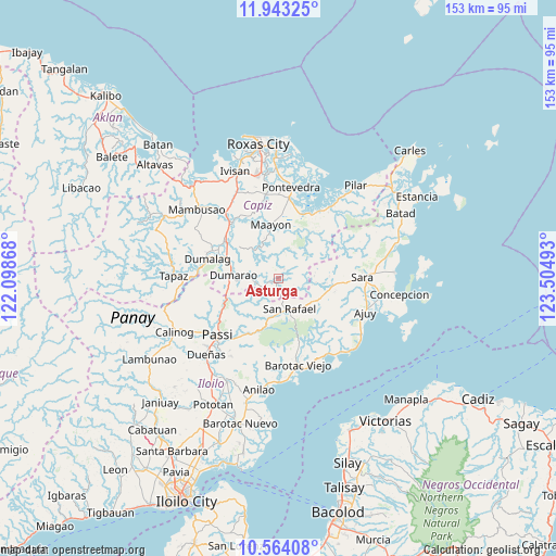
Asturga GPS coordinates[2]
11° 15' 16.164" North, 122° 48' 6.48" East
| Map corner | latitude | longitude |
|---|---|---|
| Upper-left | 11.94325°, | 122.09868° |
| Center: | 11.25449°, | 122.8018° |
| Lower-right: | 10.56408°, | 123.50493° |
| Map W x H: | 153.3×153.4 km | = 95.3×95.3mi |
| max Lat: | 20.78733° ⇑53.8% North |
| Asturga: | 11.25449° |
| min Lat: | ⇓46.2% South 4.65442° |
| min Long | Asturga | max Long |
| 117.04868° | 122.8018° | 126.58417° |
| W 49.8%⇐ | ⇒50.2% E |
Elevation
Elevation of Asturga is 71 m = 233 ft, and this is 16.9 m = 55 ft below average elevation for this country.
| Max E: |
2262 m = 7421 ft | 24.2% |
| Avg. | 87.9 m = 288 ft | |
| Asturga | 71 m = 233 ft | |
Min E: |
-2 m = -7 ft | 75.8% |
See also: Philippines elevation on elevation.city.
Geographical zone
Asturga is located in North Torrid zone (between Equator and Tropic of Cancer). Distance of Equator is 1251.4 km =777.6 mi to South.| Distance of | km | miles | from Asturga |
|---|---|---|---|
| North Pole | 8755.7 | 5440.5 | to North |
| Arctic Circle | 6149.8 | 3821.3 | to North |
| Tropic Cancer | 1354.5 | 841.6 | to North |
| Equator | 1251.4 | 777.6 | to South |


Nearby cities:
15 places around Asturga: (largest is in red/bold)
• Abaca
16.3 km =10.1 mi,  215°
215°
• Aglalana
17.8 km =11.1 mi,  242°
242°
• Alimono
12.4 km =7.7 mi,  231°
231°
• Binantocan
18.1 km =11.2 mi,  20°
20°
• Bungsuan
11.5 km =7.1 mi,  262°
262°
• Cuartero
17.3 km =10.7 mi,  303°
303°
• Dumarao
12.4 km =7.7 mi,  275°
275°
• Gibato
3.5 km =2.2 mi,  157°
157°
• Jaguimitan
15.3 km =9.5 mi,  213°
213°
• Lantangan
17.4 km =10.8 mi,  32°
32°
• Lemery
14.1 km =8.8 mi,  103°
103°
• Maayon
14.8 km =9.2 mi,  353°
353°
• Manjoy
18.4 km =11.4 mi,  306°
306°
• Mapili
17.6 km =10.9 mi,  202°
202°
• San Rafael
8.9 km =5.5 mi, 161°
Sources, notices
• [Note1] Compared only with cities in Philippines existing in our database
• [Src1] Map data: © OpenStreetMap contributors (CC-BY-SA)
• [Src2] Other city data from geonames.org with taken over terms of usage.
• [Src3] Geographical zone / Annual Mean Temperature by Robert A. Rohde @ Wikipedia
