Laurel geodata
Laurel (Calabarzon) is a seat of a third-order administrative division; located in Philippines in Asia/Manila (GMT+8) time zone. With population of 9,720 people, there are 631 cities with bigger population in this country. Compared to other cities in Philippines, 69.9% of cities are located further ↓South; 78.7% of cities are located further →East and 78.3% of cities have lower elevation than Laurel. Note1


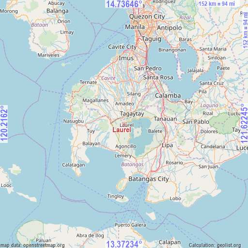
Laurel GPS coordinates[2]
14° 3' 19.512" North, 120° 55' 9.552" East
| Map corner | latitude | longitude |
|---|---|---|
| Upper-left | 14.73646°, | 120.2162° |
| Center: | 14.05542°, | 120.91932° |
| Lower-right: | 13.37234°, | 121.62245° |
| Map W x H: | 151.7×151.7 km | = 94.3×94.3mi |
| max Lat: | 20.78733° ⇑30.1% North |
| Laurel: | 14.05542° |
| min Lat: | ⇓69.9% South 4.65442° |
| min Long | Laurel | max Long |
| 117.04868° | 120.91932° | 126.58417° |
| W 21.3%⇐ | ⇒78.7% E |
Elevation
Elevation of Laurel is 81 m = 266 ft, and this is 6.9 m = 23 ft below average elevation for this country.
| Max E: |
2262 m = 7421 ft | 21.7% |
| Avg. | 87.9 m = 288 ft | |
| Laurel | 81 m = 266 ft | |
Min E: |
-2 m = -7 ft | 78.3% |
See also: Philippines elevation on elevation.city.
Geographical zone
Laurel is located in North Torrid zone (between Equator and Tropic of Cancer). Distance of this Northern Tropic circle is 1043.1 km =648.2 mi to North.| Distance of | km | miles | from Laurel |
|---|---|---|---|
| North Pole | 8444.2 | 5247 | to North |
| Arctic Circle | 5838.4 | 3627.8 | to North |
| Tropic Cancer | 1043.1 | 648.2 | to North |
| Equator | 1562.8 | 971.1 | to South |


Nearby cities:
15 places around Laurel: (largest is in red/bold)
• Alfonso
11.8 km =7.3 mi,  323°
323°
• Anuling
8.2 km =5.1 mi,  338°
338°
• Bugaan
2.5 km =1.6 mi,  133°
133°
• Kaytitinga
11.3 km =7 mi,  300°
300°
• Luksuhin
6.2 km =3.9 mi, 317°
• Malabag
12.2 km =7.6 mi,  24°
24°
• Mangas
9 km =5.6 mi, 320°
• Matagbak
12.4 km =7.7 mi,  312°
312°
• Mendez-Nuñez
8.3 km =5.2 mi,  349°
349°
• Patuto
8.5 km =5.3 mi,  36°
36°
• Payapa
7 km =4.3 mi,  204°
204°
• Sampaloc
6.6 km =4.1 mi,  57°
57°
• Subic
12.1 km =7.5 mi,  169°
169°
• Tagaytay
4.7 km =2.9 mi, 19°
• Talisay
11.8 km =7.3 mi,  69°
69°
Sources, notices
• [Note1] Compared only with cities in Philippines existing in our database
• [Src1] Map data: © OpenStreetMap contributors (CC-BY-SA)
• [Src2] Other city data from geonames.org with taken over terms of usage.
• [Src3] Geographical zone / Annual Mean Temperature by Robert A. Rohde @ Wikipedia
