Kabalen geodata
Kabalen (Soccsksargen) is a populated place; located in Philippines in Asia/Manila (GMT+8) time zone. With population of 4,852 people, there are 1358 cities with bigger population in this country. Compared to other cities in Philippines, 96.6% of cities are located further ↑North; 87.8% of cities are located further ←West and 97% of cities have lower elevation than Kabalen. Note1


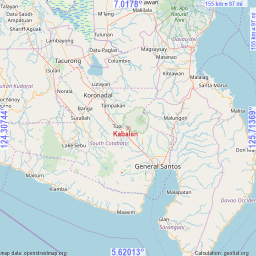
Kabalen GPS coordinates[2]
6° 19' 9.984" North, 125° 0' 38.016" East
| Map corner | latitude | longitude |
|---|---|---|
| Upper-left | 7.0178°, | 124.30744° |
| Center: | 6.31944°, | 125.01056° |
| Lower-right: | 5.62013°, | 125.71369° |
| Map W x H: | 155.4×155.4 km | = 96.6×96.6mi |
| max Lat: | 20.78733° ⇑96.6% North |
| Kabalen: | 6.31944° |
| min Lat: | ⇓3.4% South 4.65442° |
| min Long | Kabalen | max Long |
| 117.04868° | 125.01056° | 126.58417° |
| W 87.8%⇐ | ⇒12.2% E |
Elevation
Elevation of Kabalen is 621 m = 2037 ft, and this is 533.1 m = 1749 ft above average elevation for this country.
| Max E: |
2262 m = 7421 ft | 3% |
| Kabalen | 621 m 2037 ft | |
| Avg. | 87.9 m = 288 ft | |
Min E: |
-2 m = -7 ft | 97% |
See also: Philippines elevation on elevation.city.
Geographical zone
Kabalen is located in North Torrid zone (between Equator and Tropic of Cancer). Distance of Equator is 702.7 km =436.6 mi to South.| Distance of | km | miles | from Kabalen |
|---|---|---|---|
| North Pole | 9304.4 | 5781.5 | to North |
| Arctic Circle | 6698.5 | 4162.3 | to North |
| Tropic Cancer | 1903.3 | 1182.7 | to North |
| Equator | 702.7 | 436.6 | to South |


Nearby cities:
15 places around Kabalen: (largest is in red/bold)
• Cebuano
8.9 km =5.5 mi,  328°
328°
• Kipalbig
13.8 km =8.6 mi,  317°
317°
• Koronadal
8.7 km =5.4 mi,  197°
197°
• Lampitak
13.4 km =8.3 mi,  20°
20°
• Linan
13.1 km =8.1 mi,  343°
343°
• Lunen
12.5 km =7.8 mi,  290°
290°
• Maltana
14.1 km =8.8 mi, 324°
• Pagalungan
6 km =3.7 mi,  177°
177°
• Palian
12.6 km =7.8 mi,  298°
298°
• Palkan
3.5 km =2.2 mi,  137°
137°
• Polo
12.8 km =8 mi,  118°
118°
• Polomolok
12.4 km =7.7 mi,  151°
151°
• Polonoling
6 km =3.7 mi,  230°
230°
• Sulit
9.3 km =5.8 mi,  173°
173°
• Tupi
6.6 km =4.1 mi,  284°
284°
Sources, notices
• [Note1] Compared only with cities in Philippines existing in our database
• [Src1] Map data: © OpenStreetMap contributors (CC-BY-SA)
• [Src2] Other city data from geonames.org with taken over terms of usage.
• [Src3] Geographical zone / Annual Mean Temperature by Robert A. Rohde @ Wikipedia
