Polomolok geodata
Polomolok (Soccsksargen) is a seat of a third-order administrative division; located in Philippines in Asia/Manila (GMT+8) time zone. With population of 63,987 people, there are 149 cities with bigger population in this country. Compared to other cities in Philippines, 97.1% of cities are located further ↑North; 88.9% of cities are located further ←West and 92.4% of cities have lower elevation than Polomolok. Note1
Administrative division(s):
- Level 1: Soccsksargen
- Level 2: Province of South Cotabato
- Level 3: Polomolok


Polomolok GPS coordinates[2]
6° 13' 18.012" North, 125° 3' 50.328" East
| Map corner | latitude | longitude |
|---|---|---|
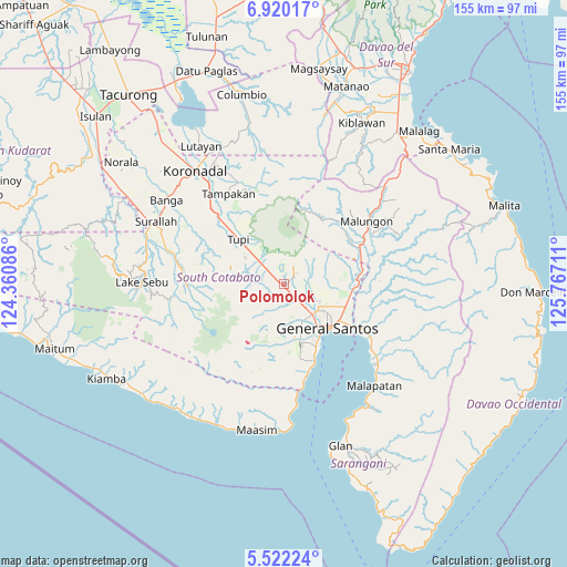
| Upper-left | 6.92017°, | 124.36086° |
| Center: | 6.22167°, | 125.06398° |
| Lower-right: | 5.52224°, | 125.76711° |
| Map W x H: | 155.4×155.4 km | = 96.6×96.6mi |
| max Lat: | 20.78733° ⇑97.1% North |
| Polomolok: | 6.22167° |
| min Lat: | ⇓2.9% South 4.65442° |
| min Long | Polomolok | max Long |
| 117.04868° | 125.06398° | 126.58417° |
| W 88.9%⇐ | ⇒11.1% E |
Elevation
Elevation of Polomolok is 300 m = 984 ft, and this is 212.1 m = 696 ft above average elevation for this country.
| Max E: |
2262 m = 7421 ft | 7.6% |
| Polomolok | 300 m 984 ft | |
| Avg. | 87.9 m = 288 ft | |
Min E: |
-2 m = -7 ft | 92.4% |
See also: Polomolok elevation on elevation.city.
Geographical zone
Polomolok is located in North Torrid zone (between Equator and Tropic of Cancer). Distance of Equator is 691.8 km =429.9 mi to South.| Distance of | km | miles | from Polomolok |
|---|---|---|---|
| North Pole | 9315.3 | 5788.3 | to North |
| Arctic Circle | 6709.4 | 4169 | to North |
| Tropic Cancer | 1914.1 | 1189.4 | to North |
| Equator | 691.8 | 429.9 | to South |


Nearby cities:
15 places around Polomolok: (largest is in red/bold)
• Conel
13.8 km =8.6 mi,  99°
99°
• General Santos
17 km =10.6 mi,  135°
135°
• Glamang
6.9 km =4.3 mi,  161°
161°
• Kabalen
12.4 km =7.7 mi,  331°
331°
• Katangawan
18.2 km =11.3 mi,  107°
107°
• Klinan
8.9 km =5.5 mi,  115°
115°
• Koronadal
8.9 km =5.5 mi,  287°
287°
• Pagalungan
7.4 km =4.6 mi,  311°
311°
• Palkan
9 km =5.6 mi,  336°
336°
• Polo
7.2 km =4.5 mi,  48°
48°
• Polonoling
12.6 km =7.8 mi,  303°
303°
• Silway 7
8 km =5 mi,  128°
128°
• Sulit
5.1 km =3.2 mi, 288°
• Tupi
17.6 km =10.9 mi,  315°
315°
• Upper Klinan
6.3 km =3.9 mi,  84°
84°
Sources, notices
• [Note1] Compared only with cities in Philippines existing in our database
• [Src1] Map data: © OpenStreetMap contributors (CC-BY-SA)
• [Src2] Other city data from geonames.org with taken over terms of usage.
• [Src3] Geographical zone / Annual Mean Temperature by Robert A. Rohde @ Wikipedia
