Tupi geodata
Tupi (Soccsksargen) is a seat of a third-order administrative division; located in Philippines in Asia/Manila (GMT+8) time zone. With population of 16,518 people, there are 416 cities with bigger population in this country. Compared to other cities in Philippines, 96.6% of cities are located further ↑North; 86.8% of cities are located further ←West and 92.7% of cities have lower elevation than Tupi. Note1


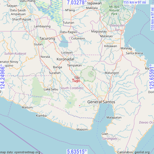
Tupi GPS coordinates[2]
6° 20' 3.984" North, 124° 57' 10.008" East
| Map corner | latitude | longitude |
|---|---|---|
| Upper-left | 7.03278°, | 124.24966° |
| Center: | 6.33444°, | 124.95278° |
| Lower-right: | 5.63515°, | 125.65591° |
| Map W x H: | 155.4×155.4 km | = 96.6×96.6mi |
| max Lat: | 20.78733° ⇑96.6% North |
| Tupi: | 6.33444° |
| min Lat: | ⇓3.4% South 4.65442° |
| min Long | Tupi | max Long |
| 117.04868° | 124.95278° | 126.58417° |
| W 86.8%⇐ | ⇒13.2% E |
Elevation
Elevation of Tupi is 317 m = 1040 ft, and this is 229.1 m = 752 ft above average elevation for this country.
| Max E: |
2262 m = 7421 ft | 7.3% |
| Tupi | 317 m 1040 ft | |
| Avg. | 87.9 m = 288 ft | |
Min E: |
-2 m = -7 ft | 92.7% |
See also: Philippines elevation on elevation.city.
Geographical zone
Tupi is located in North Torrid zone (between Equator and Tropic of Cancer). Distance of Equator is 704.3 km =437.6 mi to South.| Distance of | km | miles | from Tupi |
|---|---|---|---|
| North Pole | 9302.7 | 5780.4 | to North |
| Arctic Circle | 6696.9 | 4161.3 | to North |
| Tropic Cancer | 1901.6 | 1181.6 | to North |
| Equator | 704.3 | 437.6 | to South |


Nearby cities:
15 places around Tupi: (largest is in red/bold)
• Cebuano
6.2 km =3.9 mi,  16°
16°
• Kabalen
6.6 km =4.1 mi,  104°
104°
• Kipalbig
9 km =5.6 mi,  340°
340°
• Koronadal
10.7 km =6.6 mi,  158°
158°
• Lamian
12.1 km =7.5 mi,  256°
256°
• Lampari
8.4 km =5.2 mi,  253°
253°
• Liberty
13.8 km =8.6 mi,  13°
13°
• Linan
11.2 km =7 mi, 13°
• Lunen
6 km =3.7 mi,  297°
297°
• Maltana
10 km =6.2 mi,  349°
349°
• Pagalungan
10.2 km =6.3 mi,  138°
138°
• Palian
6.4 km =4 mi,  313°
313°
• Palkan
9.7 km =6 mi,  115°
115°
• Polonoling
5.8 km =3.6 mi, 162°
• Sulit
13.3 km =8.3 mi,  145°
145°
Sources, notices
• [Note1] Compared only with cities in Philippines existing in our database
• [Src1] Map data: © OpenStreetMap contributors (CC-BY-SA)
• [Src2] Other city data from geonames.org with taken over terms of usage.
• [Src3] Geographical zone / Annual Mean Temperature by Robert A. Rohde @ Wikipedia
